Summary
Español:
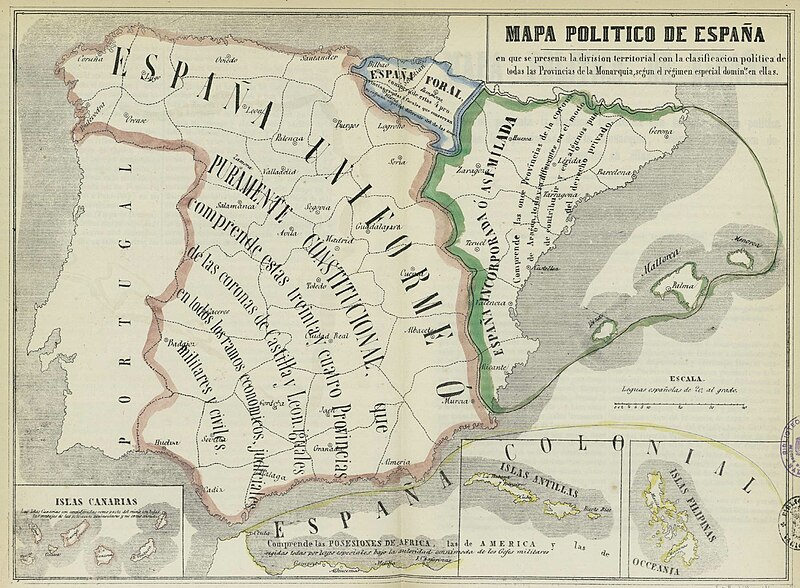
Mapa de España en que se presenta la división territorial con la clasificación de todas las Provincias de la Monarquía según el régimen legal especial común en ellos (Jorge Torres Villegas, 1852).
English:
Map of Spain in which is shown the territorial division with the classification of all the provinces of the monarchy under the special legal regime common in them (Jorge Torres Villegas, 1852).
Source
This map comes from:
-
Francisco Jorge Torres Villegas,
Cartografía hispano-científica ó sea los mapas españoles en que se representa bajo sus diferentes fases
. Imprenta de don José María Alonso, 1852 (1ª ed.) y 1857 (2ª ed.).
-
(
Spanish Scientific cartography, that is the Maps about Spain in which it is represented its evolution
. Printed by Mr. Jose Maria Alonso, 1852 and 1857, two eds.)
This copy is from the Spanish National Library in Madrid (
Link to entry in the Catalogue
).
Original link
Wayback Machine
.
Text on the map
Top (Title)
«Mapa de España en que se presenta la división territorial con la clasificación de todas las Provincias de la Monarquía según el régimen legal especial común en ellos».
English:
“Map of Spain in which the territorial division is presented based on provinces grouped according to their common special laws.”
Orange-surrounded area
«España Uniforme ó Puramente Constitucional que comprende estas treinta y cuatro Provincias de las coronas de Castilla y León, iguales en todos los ramos económicos, judiciales, militares y civiles».
English:
“Uniform or Purely Constitutional Spain, which comprises these thirty-four Provinces of the Crowns of Castile and Leon, equal in all economic, judicial, military, and civil branches.”
Former kingdoms of Castile, León and Granada.
Green-surrounded area
«España Incorporada ó Asimilada que comprende las once provincias de la Corona de Aragón, todavía diferentes en el modo de contribuir y en algunos puntos del derecho privado».
English:
“Incorporated or Assimilated Spain, which comprises the eleven provinces of the Crown of Aragon, still different in the manner of contribution and in some points of private law.”
Crown of Aragón
Blue-surrounded area
«España Foral».
English:
“Spain of the Fueros,” or approximately “Statutory Spain.”
Navarre and the
Provincias Vascongadas
Overseas
«España Colonial».
English:
“Colonial Spain.”
|
Public domain
Public domain
false
false
|

|
This work is in the
public domain
in its country of origin and other countries and areas where the
copyright term
is the author's
life plus 70 years or fewer
.
 You must also include a
United States public domain tag
to indicate why this work is in the public domain in the United States. Note that a few countries have copyright terms longer than 70 years: Mexico has 100 years, Jamaica has 95 years, Colombia has 80 years, and Guatemala and Samoa have 75 years. This image may
not
be in the public domain in these countries, which moreover do
not
implement the
rule of the shorter term
. Honduras has a general copyright term of 75 years, but it
does
implement the rule of the shorter term. Copyright may extend on works created by French who died for France in
World War II
(
more information
), Russians who served in
the Eastern Front of World War II
(known as the Great Patriotic War in Russia) and posthumously
rehabilitated
victims of Soviet repressions (
more information
).
You must also include a
United States public domain tag
to indicate why this work is in the public domain in the United States. Note that a few countries have copyright terms longer than 70 years: Mexico has 100 years, Jamaica has 95 years, Colombia has 80 years, and Guatemala and Samoa have 75 years. This image may
not
be in the public domain in these countries, which moreover do
not
implement the
rule of the shorter term
. Honduras has a general copyright term of 75 years, but it
does
implement the rule of the shorter term. Copyright may extend on works created by French who died for France in
World War II
(
more information
), Russians who served in
the Eastern Front of World War II
(known as the Great Patriotic War in Russia) and posthumously
rehabilitated
victims of Soviet repressions (
more information
).
|
|
This file has been identified as being free of known restrictions under copyright law, including all related and neighboring rights.
|
https://creativecommons.org/publicdomain/mark/1.0/
PDM
Creative Commons Public Domain Mark 1.0
false
false
