Mapbeer.jpg

Size of this preview:
799 × 382 pixels
.
Other resolutions:
320 × 153 pixels
|
640 × 306 pixels
|
1,024 × 490 pixels
|
1,872 × 895 pixels
.


Summary
| Description |
English:
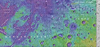
Map showing the location of Beer Crater and other, nearby features
|
| Date | |
| Source | https://planetarynames.wr.usgs.gov/images/mc19_2014.pdf |
| Author | Jim Secosky modified NASA image. NASA/USGS |
Licensing
|
|
This file is in the public domain in the United States because it was solely created by NASA . NASA copyright policy states that "NASA material is not protected by copyright unless noted ". (See Template:PD-USGov , NASA copyright policy page or JPL Image Use Policy .) |
|

|
Warnings:
|