Maps_template-en.svg

Size of this PNG preview of this SVG file:
365 × 598 pixels
.
Other resolutions:
146 × 240 pixels
|
293 × 480 pixels
|
468 × 768 pixels
|
624 × 1,024 pixels
|
1,249 × 2,048 pixels
|
1,096 × 1,797 pixels
.
| Description |
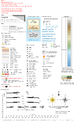
English:
Template of
Wikipedia map conventions
.
Français :
Version anglais. Modèle pour la création de cartes géographiques et topographiques avec les principaux éléments habituellement employés et qui suit les conventions cartographiques actuelles de WP-fr et pour certains éléments en partie dans WP-de. (Pour le version Français,
cliquez ici
.)
|
||||||||
| Date | 29 November 2014 (English translation); 14 October 2012 (French original work) | ||||||||
| Source |
|
||||||||
| Author | Eric Gaba ( Sting - fr:Sting ) | ||||||||
|
Permission
( Reusing this file ) |
I, the copyright holder of this work, hereby publish it under the following licenses:
This file is licensed under the
Creative Commons
Attribution 2.5 Generic
license.
You may select the license of your choice.
|
||||||||
| Other versions |
English:
Versions of the Maps template, a toolbox helping wiki-mapmakers and contains icons and formatted text/objects that serve as a template for
Wikipedia map conventions
. The French version is the 'mother one', the first to be updated, and is frequently improved and updated following calm talks between mapmakers. Experienced cartographers may propose (using English) a new icon on
this talkpage
.
|


W3C-validity not checked.
Original upload log
This image is a derivative work of the following images:
-
File:Maps_template-fr.svg
licensed with Cc-by-2.5, Cc-by-2.5, GFDL, GFDL/en
- 2009-01-27T13:06:03Z Yug 1100x1500 (203738 Bytes) MINOR UPDATES: 2009/01/27. Add: port ; bat. judaisme, bat. chinese religions. Correct: terre principal fefee4 -> fefee9 (german usage) Add frames' titles, legend box. Move frames to more suitable place.
- 2008-09-04T00:08:14Z Sting 1100x1500 (176632 Bytes) Several little improvements
- 2008-07-15T14:45:27Z Sting 1100x1500 (170548 Bytes) Some improvements
- 2008-06-24T01:02:19Z Sting 1100x1500 (170673 Bytes) Valors for elevations and depths deleted to avoid confusion
- 2008-06-23T18:53:20Z Sémhur 1100x1500 (170836 Bytes) Change lighthouse icon, and decrease weight
- 2008-06-22T14:26:16Z Sting 1100x1500 (209351 Bytes) Additional topo colors for high elevations/permanent snow areas
- 2008-06-18T13:06:33Z Sting 1100x1500 (202960 Bytes) Additional modifications
- 2008-06-17T02:19:19Z Sting 1100x1500 (202606 Bytes) Some slight modifications
- 2008-06-13T14:51:52Z Sting 1100x1500 (202325 Bytes) Linear scales reduced to one type
- 2008-06-11T22:30:44Z Sting 1100x1500 (331785 Bytes) Some adjustments
- 2008-06-11T03:57:09Z Sting 1100x1500 (324893 Bytes) == Summary == {{Information |Description={{en|Template for the creation of geographic and topographic maps with the most common features used and following the convention to be used in the whole Wikimedia projet. *'''''Import
Uploaded with derivativeFX