Marchwood_Power_Station,_East_Road_-_geograph.org.uk_-_1107872.jpg
No higher resolution available.
Summary
| Description |
English:
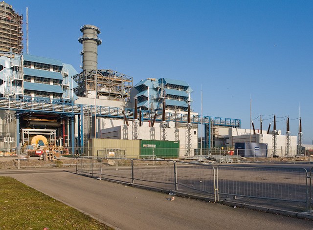
Marchwood Power Station, East Road. Under construction. The station combines gas and steam turbines to generate 824 MW at 58% efficiency; it will cost £380m to build, see
http://www.marchwoodpower.com
. I presume that the blue vents are air intakes for the gas turbines, and that the two cylindrical stacks are chimneys. Centre right can be seen the two step-up transformers that convert the output of the generators from about 27 KV to the 400 KV needed for feeding into the national grid. Each transformer is surrounded by a white concrete wall to limit damage should it explode or catch fire. Each phase of the 400 KV output passes via an underground cable to the National Grid Substation seen at left of
1107787
|
| Date | |
| Source | From geograph.org.uk |
| Author | Peter Facey |
|
Attribution
( required by the license ) |
Peter Facey / Marchwood Power Station, East Road / |
| Camera location |
|
View this and other nearby images on: OpenStreetMap |
|
|---|
_heading:67.00&language=en)
| Object location |
|
View this and other nearby images on: OpenStreetMap |
|
|---|
_heading:67.00&language=en)
Licensing

|
This image was taken from the
Geograph project
collection. See
this photograph's page
on the Geograph website for the photographer's contact details. The copyright on this image is owned by
Peter Facey
and is licensed for reuse under the
Creative Commons
Attribution-ShareAlike 2.0 license.
|
This file is licensed under the
Creative Commons
Attribution-Share Alike 2.0 Generic
license.
Attribution:
Peter Facey
-
You are free:
- to share – to copy, distribute and transmit the work
- to remix – to adapt the work
-
Under the following conditions:
- attribution – You must give appropriate credit, provide a link to the license, and indicate if changes were made. You may do so in any reasonable manner, but not in any way that suggests the licensor endorses you or your use.
- share alike – If you remix, transform, or build upon the material, you must distribute your contributions under the same or compatible license as the original.