MarsTopoMap-PIA02031_modest.jpg

Size of this preview:
674 × 600 pixels
.
Other resolutions:
270 × 240 pixels
|
540 × 480 pixels
|
864 × 768 pixels
|
1,151 × 1,024 pixels
|
2,497 × 2,221 pixels
.
Summary


| Description |
English:
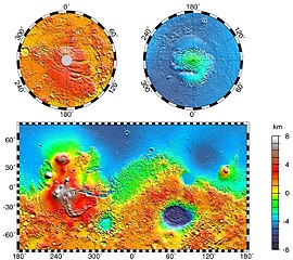
Maps of Mars' global topography. The projections are Mercator to 70° latitude and stereographic at the poles with the south pole at left and north pole at right. Note the elevation difference between the northern and southern hemispheres. The Tharsis volcano-tectonic province is centered near the equator in the longitude range 220° E to 300° E and contains the vast east-west trending Valles Marineris canyon system and several major volcanic shields including Olympus Mons (18° N, 225° E), Alba Patera (42° N, 252° E), Ascraeus Mons (12° N, 248° E), Pavonis Mons (0°, 247° E), and Arsia Mons (9° S, 239° E). Regions and structures discussed in the text include Solis Planum (25° S, 270° E), Lunae Planum (10° N, 290° E), and Claritas Fossae (30° S, 255° E). Major impact basins include Hellas (45° S, 70° E), Argyre (50° S, 320° E), Isidis (12° N, 88° E), and Utopia (45° N, 110° E). This analysis uses an areocentric coordinate convention with east longitude positive.
Русский:
Топографическая карта Марса.
|
| Date | |
| Source |
http://photojournal.jpl.nasa.gov/jpeg/PIA02031.jpg
|
| Author | NASA/JPL-Caltech/GSFC |
|
Permission
( Reusing this file ) |
PD-USGOV-NASA |
|
|
This image or video was catalogued by Jet Propulsion Laboratory of the United States
National Aeronautics and Space Administration
(NASA) under
Photo ID:
PIA02031
.
This tag does not indicate the copyright status of the attached work. A normal copyright tag is still required. See Commons:Licensing .
Other languages:
|
Licensing
|
|
This file is in the public domain in the United States because it was solely created by NASA . NASA copyright policy states that "NASA material is not protected by copyright unless noted ". (See Template:PD-USGov , NASA copyright policy page or JPL Image Use Policy .) |
|

|
Warnings:
|
Original upload log
The original description page was
here
. All following user names refer to en.wikipedia.
- 2004-05-06 16:52 Wwoods 612×545×8 (88223 bytes) Topographic Map of Mars; http://photojournal.jpl.nasa.gov/catalog/PIA02031 ; {{msg:PD}}
| Annotations | This image is annotated: View the annotations at Commons |


