MatheranPanoramaPointMonsoon.JPG

Size of this preview:
799 × 217 pixels
.
Other resolutions:
320 × 87 pixels
|
640 × 174 pixels
|
1,024 × 278 pixels
|
1,280 × 348 pixels
|
2,560 × 696 pixels
|
7,975 × 2,167 pixels
.
Summary
| Description |
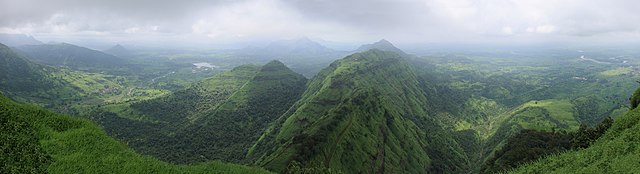
English:
Panoramic View during rain season from the Panorama Point on the Matheran Hill. On the ridge in front you can see the railroad track wriggling around.
Deutsch:
Panorama vom Panorama Point auf dem Metheran-Hügel während der Regenzeit. Auf dem Grat im Vordergrund sieht man, wie sich die Bahnstrecke schlängelt.
ગુજરાતી:
માથેરાન ટેકરી પરના પેનોરમા પોઇન્ટથી વરસાદની ઋતુમાં મનોહર દૃશ્ય. સામેની પર્વતીય પટ્ટી પર તમે રેલવે ટ્રેકને ચારેતરફ ઘૂમતી જોઈ શકો છો.
|
| Date | |
| Source | Own work |
| Author | Arne Hückelheim |
|
Permission
( Reusing this file ) |
|
| Other versions |
|


| Camera location |
|
View this and other nearby images on: OpenStreetMap |
|
|---|
|
|
This is a
retouched picture
, which means that it has been digitally altered from its original version. Modifications:
Apparently, bottom left and right corners (for which no photos were available) were filled with material copied from neighboring areas
.
|
Licensing
I, the copyright holder of this work, hereby publish it under the following licenses:
This file is licensed under the
Creative Commons
Attribution-Share Alike 3.0 Unported
license.
-
You are free:
- to share – to copy, distribute and transmit the work
- to remix – to adapt the work
-
Under the following conditions:
- attribution – You must give appropriate credit, provide a link to the license, and indicate if changes were made. You may do so in any reasonable manner, but not in any way that suggests the licensor endorses you or your use.
- share alike – If you remix, transform, or build upon the material, you must distribute your contributions under the same or compatible license as the original.

|
Permission is granted to copy, distribute and/or modify this document under the terms of the GNU Free Documentation License , Version 1.2 or any later version published by the Free Software Foundation ; with no Invariant Sections, no Front-Cover Texts, and no Back-Cover Texts. A copy of the license is included in the section entitled GNU Free Documentation License . |
You may select the license of your choice.
|
|
This image has been assessed using the
Quality image guidelines
and is considered a
Quality image
.
|