Megalópoles_na_China.svg

Size of this PNG preview of this SVG file:
290 × 234 pixels
.
Other resolutions:
298 × 240 pixels
|
595 × 480 pixels
|
952 × 768 pixels
|
1,269 × 1,024 pixels
|
2,538 × 2,048 pixels
.
Summary
| Description |
Português:
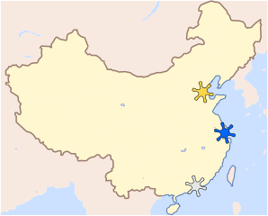
Mapa de localização das megalópoles chinesas: deltas do Rio Amarelo, do Rio Azul e do Rio das Pérolas (do norte para o sul).
|
| Date | (UTC) |
| Source |
This file was derived from:
Mapa China.svg
:
|
| Author |
|
| Other versions |

|
|
|
This is a
retouched picture
, which means that it has been digitally altered from its original version. The original can be viewed here:
Mapa China.svg
:
|
Licensing
Luan
, the copyright holder of this work, hereby publishes it under the following license:
This file is licensed under the
Creative Commons
Attribution-Share Alike 3.0 Brazil
license.
Attribution:
Luan
-
You are free:
- to share – to copy, distribute and transmit the work
- to remix – to adapt the work
-
Under the following conditions:
- attribution – You must give appropriate credit, provide a link to the license, and indicate if changes were made. You may do so in any reasonable manner, but not in any way that suggests the licensor endorses you or your use.
- share alike – If you remix, transform, or build upon the material, you must distribute your contributions under the same or compatible license as the original.


|
I'd greatly appreciate, that you attribute this media file to
Wikimedia Commons
, if used outside Wikipedia or Commons. For use in publications such as books, newspapers, blogs, websites, please insert
here
the following line:
Attribution: Luan
|
Original upload log
This image is a derivative work of the following images:
-
File:Mapa China.svg
licensed with Cc-by-sa-3.0-migrated, GFDL
- 2013-06-19T22:59:03Z Quigley 290x234 (155229 Bytes) derp
- 2013-06-19T22:55:16Z Quigley 290x234 (146992 Bytes) "Manchuria" as a concept is a Japanese Imperial fraud and has had no relevance to China since World War II (and this modern China is what the map describes, since Inner Mongolia has annexed quite a bit of former "Manchu" terr
- 2012-04-14T20:42:21Z Luan 290x234 (155991 Bytes) == {{int:filedesc}} == {{Information |Description={{Pt|Mapa da [[pt:China (civilização)|civilização chinesa]] e as regiões em amarelo que não são especificamente chinesas.}} |Source={{Derived from|Map_of_China_coal_res
Uploaded with derivativeFX