Mississippi_Delta_Lobes.jpg
No higher resolution available.
From : http://en.wikipedia.org/wiki/Image:Mississippi_Delta_Lobes.jpg
|
|
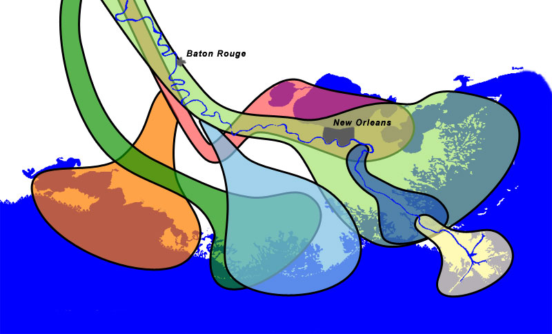
Salé-Cypremort | 4600 years BP |
|
|
Cocodrie | 4600–3500 years BP |
|
|
Teche | 3500–2800 years BP |
|
|
St. Bernard | 2800–1000 years BP |
|
|
Lafourche | 1000–300 years BP |
|
|
Plaquemine | 750–500 years BP |
|
|
Balize | 550 years |
Summary
The lobes of the Mississippi River Delta that formed over thousands of years due to deltaic switching.


Sources
- Wicander,Monroe (1993) Historical Geology - Evolution of Earth and Life through Time , West Publishing Company ISBN 0314012400 [1]
- Kolb,van Lopik (1958) Geology of the Mississippi River deltaic plain, southeastern Louisiana. Technical Report 3-483 , Vicksburg, MS: U.S. Army Corps of Engineers Waterways Experiment Station ( PDF, 6.86MB ) [2]
- Delta Complexes of Mississippi River Deltaic Plain, Frazier, 1967 [3]
Licensing
|
|
I, the copyright holder of this work, release this work into the
public domain
. This applies worldwide.
In some countries this may not be legally possible; if so: I grant anyone the right to use this work for any purpose , without any conditions, unless such conditions are required by law. |
Coast and river images from the National Map Server . Lobe outlines originally traced directly from Wicander and Monroe, 1993, but the shorline and river didn't match the USGS data, so the outlines had to be reinterpretted slightly.
Final Photoshop layers can be found here , in case updates are needed.