Montaigu_1685_map_(detail_showing_bridge).jpg
Size of this preview:
699 × 600 pixels
.
Other resolutions:
280 × 240 pixels
|
560 × 480 pixels
|
895 × 768 pixels
|
1,090 × 935 pixels
.
Summary
| Artist |
Jean François de Montaigu
|
||||||||||||||||||||
| Description |
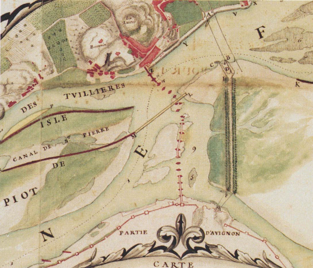
Detail of a map showing the Rhône at Avignon and the abandoned Pont Saint-Bénézet bridge in 1685. The map was produced as part of a project to block the arm of the Rhône that flowed near Avignon and to create a port on the right bank of the river near Villeneuve-lès-Avignon. The project was never realised. The map is signed by Jean François de Montaigu who was an engineer working for Louis XIV of France. The map is mentioned in Sournia & Vayssettes (2006). The 14th century ramparts of Avignon are shown in red at the bottom and Villeneuve-lès-Avignon is at the top. A-B indicates the path of the chain ferry between Villeneuve and the Île de la Barthelasse. E-F is the trackway across the island. F-G is the cable ferry from the island to the quay at Avignon. The piers of the abandoned bridge are shown in red. Only 20 of the 21 piers are shown. The omitted pier was on the river bank near the Tour Philippe-le-Bel at the top of the map. The map indicates that by this date arches 5-7 and 12-18 had collapsed.
|
||||||||||||||||||||
| Date | 15 January 1685 | ||||||||||||||||||||
| Medium | Ink and watercolour on paper | ||||||||||||||||||||
| Dimensions | Original complete map: height: 51 cm (20 in); width: 118 cm (46.4 in) | ||||||||||||||||||||
| Collection |
|
||||||||||||||||||||
| Accession number |
G7/300 folio 115
|
||||||||||||||||||||
| Notes | As of August 2018, this map by Montaigu is not listed in the online version of the catalogue of the Archives nationales. | ||||||||||||||||||||
| References | Sournia, Bernard; Vayssettes, Jean-Louis (2006). Villeneuve-lès-Avignon, histoire artistique et monumentale d'une villégiature pontificale (in French). Paris: Centre des monuments nationaux et Editions du Patrimoine. p. 284. ISBN 978-2-85822-830-0 . | ||||||||||||||||||||
| Source/Photographer | Berthelot, Michel (2014), Le Pont d'Avignon: combien de piles? | ||||||||||||||||||||
|
Permission
( Reusing this file ) |
|
||||||||||||||||||||
| Other versions |
|
||||||||||||||||||||


| Object location |
|
View this and other nearby images on: OpenStreetMap |
|
|---|
.jpg¶ms=043.953430_N_0004.805240_E_globe:Earth_class:object_type:object__&language=en)