Montana's_2nd_congressional_district_(since_2023).svg

Size of this PNG preview of this SVG file:
800 × 450 pixels
.
Other resolutions:
320 × 180 pixels
|
640 × 360 pixels
|
1,024 × 576 pixels
|
1,280 × 720 pixels
|
2,560 × 1,440 pixels
|
1,600 × 900 pixels
.
Summary
| Description |
English:
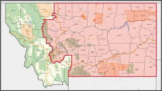
The congressional district, highlighted in red, overlayed with the other congressional district and county boundaries, as well as freeways and arterial roads, water areas, urban areas, national parks and forests, military installations, and American Indian areas (including reservations) in Montana, with neighbouring states coloured in gray. Shapefiles from
the United States Census Bureau
,
the Montana Department of Transportation
,
the United States Forest Service
, and
the National Park Service
, converted with
Mapshaper
(Mercator projection).
|
| Date | |
| Source | Own work |
| Author | Twotwofourtysix |
Licensing
I, the copyright holder of this work, hereby publish it under the following license:
This file is licensed under the
Creative Commons
Attribution-Share Alike 4.0 International
license.
-
You are free:
- to share – to copy, distribute and transmit the work
- to remix – to adapt the work
-
Under the following conditions:
- attribution – You must give appropriate credit, provide a link to the license, and indicate if changes were made. You may do so in any reasonable manner, but not in any way that suggests the licensor endorses you or your use.
- share alike – If you remix, transform, or build upon the material, you must distribute your contributions under the same or compatible license as the original.