NORAD_Region-Sector_Map.jpg
This image was
uploaded
in the
JPEG
format even though it
consists of non-photographic data
. This information could be stored more efficiently or accurately in the
PNG
or
SVG
format.
If possible, please upload a PNG or SVG version of this image without
compression artifacts
, derived from a non-JPEG source (or with existing artifacts
removed
). After doing so, please tag the JPEG version with
{{Superseded|NewImage.ext}}
and remove this tag. This tag should not be applied to photographs or scans. If this image is a diagram or other image suitable for
vectorisation
, please tag this image with
{{Convert to SVG}}
instead of
{{BadJPEG}}
. If not suitable for vectorisation, use
{{Convert to PNG}}
. For more information, see
{{BadJPEG}}
.
|
Summary
Description NORAD Region-Sector Map.jpg |
English:
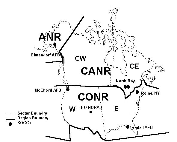
NORAD Region/Sector Map
|
Date | |
Source | http://www.NORAD.mil [ clarification needed ] |
Author | United States Air Force |
Permission
( Reusing this file ) |
USGOV-PD |
Licensing
Public domain Public domain false false |
This image or file is a work of a
U.S. Air Force
Airman or employee, taken or made as part of that person's official duties. As a
work
of the
U.S. federal government
, the image or file is in the
public domain
in the United States.
العربية ∙ беларуская (тарашкевіца) ∙ català ∙ čeština ∙ Deutsch ∙ English ∙ español ∙ eesti ∙ فارسی ∙ suomi ∙ français ∙ italiano ∙ 日本語 ∙ 한국어 ∙ македонски ∙ മലയാളം ∙ မြန်မာဘာသာ ∙ norsk bokmål ∙ Plattdüütsch ∙ Nederlands ∙ polski ∙ português ∙ português do Brasil ∙ русский ∙ sicilianu ∙ slovenčina ∙ slovenščina ∙ српски / srpski ∙ svenska ∙ Türkçe ∙ українська ∙ Tiếng Việt ∙ 中文(简体) ∙ 中文(繁體) ∙ +/− |