Nanmadol_2004-12-01_0200Z.jpg

Size of this preview:
453 × 599 pixels
.
Other resolutions:
181 × 240 pixels
|
363 × 480 pixels
|
581 × 768 pixels
|
774 × 1,024 pixels
|
1,548 × 2,048 pixels
|
6,200 × 8,200 pixels
.
Summary
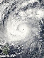
| Description | The MODIS instrument onboard NASA's Terra satellite captured this true-color image of Typhoon Nanmadol at 02:00 UTC on December 1, 2004. At the time this image was taken Nanmadol was located approximately 390 miles west-northwest of Yap and was moving at a brisk 28 mph towards the west-northwest. Maximum sustained winds were near 120 mph with higher gusts to 150 mph. | |||||
| Date | ||||||
| Source | http://earthobservatory.nasa.gov/NaturalHazards/natural_hazards_v2.php3?img_id=12597 | |||||
| Author | NASA image created by Jesse Allen, Earth Observatory, using data obtained from the MODIS Rapid Response team. | |||||
|
Permission
( Reusing this file ) |
|
