Nazaret_Verkuendigungsbasilika_BW_16.JPG

Size of this preview:
400 × 600 pixels
.
Other resolutions:
160 × 240 pixels
|
320 × 480 pixels
|
512 × 768 pixels
|
683 × 1,024 pixels
|
2,455 × 3,680 pixels
.
Summary
| Camera location |
|
View this and other nearby images on: OpenStreetMap |
|
|---|
| Description |
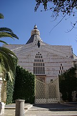
English:
Church of the Annunciation, Nazareth, Israel
Deutsch:
Verkündigungsbasilika in Nazaret
|
| Date | |
| Source | Own work |
| Author | Berthold Werner |
Licensing
|
|
I, the copyright holder of this work, release this work into the
public domain
. This applies worldwide.
In some countries this may not be legally possible; if so: I grant anyone the right to use this work for any purpose , without any conditions, unless such conditions are required by law. |
|
|
The reproduction of this architectural work, work of sculpture or work of applied art, is covered under the Israeli copyright statute (2007), which states that "Broadcasting, or copying by way of photography, drawing, sketch or similar visual description, of an architectural work, a work of sculpture or work of applied art, are permitted where the aforesaid work is permanently situated in a public place." (paragraph 23)
See COM:CRT/Israel#Freedom of panorama and COM:CRT/Israel#De minimis for more information.
|