Ordnance_Survey_1-250000_-_TF.jpg

Size of this preview:
600 × 600 pixels
.
Other resolutions:
240 × 240 pixels
|
480 × 480 pixels
|
768 × 768 pixels
|
1,024 × 1,024 pixels
|
2,048 × 2,048 pixels
|
4,000 × 4,000 pixels
.
Summary
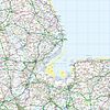
| Description |
Español
:
Un mapa de la
Ordnance Survey
de la zona TF del sistema de referencia británico, en una escala de 1:250.000.
Français
:
Une carte de l'
Ordnance Survey
de la zone TF dans le système de référence britanique, à l'échelle 1:250.000.
Italiano
:
Una carta della Ordnance Survey della zona TF nella sistema di referenza britannica, con la scala 1:250.000.


|
| Date | 6 June 2010 (upload date) |
| Source | Ordnance Survey OpenData 1:250 000 Scale Colour Raster. Converted from File:Ordnance Survey 1-250000 - TF.tif to jpg |
| Author | Ordnance Survey |
Licensing
|
|
This file is licensed by the
Ordnance Survey
of the United Kingdom under their
OS OpenData License
In short: you are free to distribute and modify the file as long as you attribute (including year), the Ordnance Survey. Attribution: Contains Ordnance Survey data © Crown copyright and database right (year)
Note: Derivative works can be licensed under any Creative Commons Attribution 3.0 Licence.
|
.svg)
|
This file is licensed under the United Kingdom Open Government Licence v3.0 . |
See also:
Meta
for information on usage on Wikimedia wikis.
|