Otsego_County_outline_map_Maryland_red.png
No higher resolution available.

|
This file was moved to Wikimedia Commons from en.wikipedia using a bot script. All source information is still present. It requires review . Additionally, there may be errors in any or all of the information fields; information on this file should not be considered reliable and the file should not be used until it has been reviewed and any needed corrections have been made. Once the review has been completed, this template should be removed. For details about this file, see below. Check now! |
Summary
| Description | |
| Date | 4 April 2006 (original upload date) |
| Source | Transferred from en.wikipedia to Commons. |
| Author | The original uploader was Cbarown at English Wikipedia . |
|
Permission
( Reusing this file ) |
Released into the public domain (by the author). |

|
This
map
image could be re-created
using
vector graphics
as an
SVG
file
. This has several advantages; see
Commons:Media for cleanup
for more information. If an SVG form of this image is available, please upload it and afterwards replace this template with
{{

vector version available

|

new image name

}}
.
It is recommended to name the SVG file “Otsego County outline map Maryland red.svg”—then the template Vector version available (or Vva ) does not need the new image name parameter. |
Licensing
=
|
|
This work has been released into the
public domain
by its author,
Cbarown
, at the
English Wikipedia
project
. This applies worldwide.
In case this is not legally possible:
|
Original upload log
The original description page was
here
. All following user names refer to en.wikipedia.
| Date/Time | Dimensions | User | Comment |
|---|---|---|---|
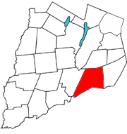
| 2006-04-04 20:31 | 180×191× (18980 bytes) | Cbarown | Map of [[Otsego County, New York]] with the Town of [[Maryland, New York]] in red |