Pahute-Mesa-Airport-Diagram.png

Size of this preview:
565 × 600 pixels
.
Other resolutions:
226 × 240 pixels
|
452 × 480 pixels
|
1,021 × 1,084 pixels
.
Summary
| Description |
English:
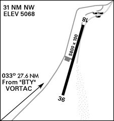
Airport Diagram for Pahute Mesa Airstrip (L23) near Mercury, Nevada
|
| Date | |
| Source | DoD Flight Information Publication (Enroute) - VFR Supplement United States |
| Author | National Geospatial-Intelligence Agency |
Licensing
|
|
This image is a work of the United States
National Geospatial-Intelligence Agency
or one of
its predecessor agencies
. As a
work
of the
U.S. federal government
, the image is in the
public domain
.
|

|