Pallava_territories.png
No higher resolution available.
Summary

|
This map has been uploaded by
Electionworld
from en.wikipedia.org to enable the
|
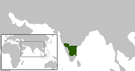
Pallava territories during Narasimhavarman I c. 645 CE. This includes the Chalukya territories occupied by the Pallavas.
Map created using the Wikipedia blank maps and modified using Adobe Photoshop
map shown here cotradicts the map shown in calukya period webpage. please retain yhe one which is historically accurate
Licensing
Venu62
, the copyright holder of this work, hereby publishes it under the following license:

|
Permission is granted to copy, distribute and/or modify this document under the terms of the GNU Free Documentation License , Version 1.2 or any later version published by the Free Software Foundation ; with no Invariant Sections, no Front-Cover Texts, and no Back-Cover Texts. A copy of the license is included in the section entitled GNU Free Documentation License . |
|
|
This file is licensed under the Creative Commons Attribution-Share Alike 3.0 Unported license. | |
| Attribution: Venu62 | ||
|
||
| This licensing tag was added to this file as part of the GFDL licensing update . |