Parinacota_Volcano,_South_America.JPG

Size of this preview:
800 × 531 pixels
.
Other resolutions:
320 × 213 pixels
|
640 × 425 pixels
|
1,024 × 680 pixels
|
1,280 × 850 pixels
|
2,560 × 1,700 pixels
|
4,288 × 2,848 pixels
.
Summary
| Description |
English:
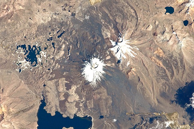
This astronaut photograph from the
International Space Station
highlights the symmetrical cone of Parinacota, with its well-developed summit crater (elevation 6,348 meters above sea level). Dark
brown
to dark
gray
surfaces
to the east and west of the summit include
lava
flows, pyroclastic deposits, and ash.
A companion volcano, Pomerape , is located across a low saddle to the north. This volcano last erupted during the Pleistocene Epoch (approximately 3 million to 12,000 years ago). Together, Parinacota and Pomerape form the Nevados de Payachata volcanic area. The summits of both volcanoes are covered by white snowpack and small glaciers . Eruptive activity at Parinacota has directly influenced development of the local landscape, beyond the placement of volcanic deposits. Approximately 8,000 years ago, the western flank of the volcano collapsed, creating a debris avalanche that travelled 22 kilometres to the west. The debris blocked rivers and streams , leading to the formation of Chungará Lake to the south (lower left). The uneven, hummocky surface of the avalanche debris provides ample catchments for water , as evidenced by the numerous small ponds and Cotacotani Lake to the west. |
| Date | |
| Source | NASA Earth Observatory |
| Author | ISS Expedition 29 crew |
| Camera location |
|
View this and other nearby images on: OpenStreetMap |
|
|---|
|
|
This image or video was catalogued by Johnson Space Center of the United States
National Aeronautics and Space Administration
(NASA) under
Photo ID:
ISS029-E-20003
.
This tag does not indicate the copyright status of the attached work. A normal copyright tag is still required. See Commons:Licensing .
Other languages:
|
Image acquired with a Nikon D2Xs digital camera using a 400 mm lens, and is provided by the ISS Crew Earth Observations experiment and Image Science & Analysis Laboratory, Johnson Space Center.
Licensing
|
|
This file is in the public domain in the United States because it was solely created by NASA . NASA copyright policy states that "NASA material is not protected by copyright unless noted ". (See Template:PD-USGov , NASA copyright policy page or JPL Image Use Policy .) |
|

|
Warnings:
|
| Annotations | This image is annotated: View the annotations at Commons |