Plan_of_St._Lucia,_in_the_West_Indies-_Shewing_the_positions_of_the_English_and_French_forces_with_the_attacks_made_at_its_reduction_in_Decr._1778._LOC_74696150.jpg

Size of this preview:
800 × 598 pixels
.
Other resolutions:
320 × 239 pixels
|
640 × 479 pixels
|
1,024 × 766 pixels
|
1,280 × 957 pixels
|
2,560 × 1,915 pixels
|
3,107 × 2,324 pixels
.
Summary
| Description |
English:
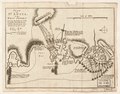
Scale ca. 1:51,000. Relief shown by hachures. Oriented with north to the left. Shows attacks made on Dec. 13-Dec. 16. Includes descriptive text. LC Maps of North America, 1750-1789, 2073 Available also through the Library of Congress Web site as a raster image. Vault AACR2: 651/1; 651/2
|
||
| Title | Plan of St. Lucia, in the West Indies: Shewing the positions of the English and French forces with the attacks made at its reduction in Decr. 1778. | ||
| Shelf ID | G5111.S2 1778 .B6 | ||
| Date | |||
| Source | https://www.loc.gov/item/74696150/ | ||
| Author | Bowen, Thomas | ||
|
Permission
( Reusing this file ) |
|
||
| Other versions |
|
||
| Location | Saint Lucia. · Saint Lucia | ||
| Part of | Military Battles And Campaigns · American Memory · Catalog · Geography And Map Division · American Revolution And Its Era: Maps And Charts Of North America And The West Indies, 1750-1789 | ||
| Subject | Saint Lucia, Battle Of, Saint Lucia · Maps · Early Works To 1800 · Saint Lucia · History |


Licensing
|
This is a faithful photographic reproduction of a two-dimensional,
public domain
work of art. The work of art itself is in the public domain for the following reason:
The official position taken by the Wikimedia Foundation is that "
faithful reproductions of two-dimensional public domain works of art are public domain
".
This photographic reproduction is therefore also considered to be in the public domain in the United States. In other jurisdictions, re-use of this content may be restricted; see Reuse of PD-Art photographs for details. |
||||