Plansee.jpg

Size of this preview:
800 × 521 pixels
.
Other resolutions:
320 × 208 pixels
|
640 × 417 pixels
|
1,024 × 667 pixels
.
| Description |
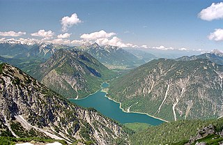
Deutsch:
Plansee
, Österreich, Bezirk
Reutte
, von Südosten, in der Mitte der Abfluss durch den Kleinen Plansee bzw. den Archbach in Richtung
Lechtal
.
Im Hintergrund links ein Teil des Hauptkamms der
Allgäuer Alpen
mit den Krottenköpfen (2180m), Leilachspitze (2274m), Lachenspitze (2130m), Schochenspitze (2069m), Sulzspitze (2084m) und Litnisschrofen (2069m). In der Hintergrundmitte die
Tannheimer Berge
mit Kellenspitze (2238m), Gehrenspitze (2163m) und Hahleskopf (1758m). Am rechten Bildrand ist der
Säuling
(2048m) zu sehen. Der Bildmittelgrund zeigt links über dem Seeufer den Tauern-Gipfel (1841m), rechts Schelleleskopf (1722m) und Hochjoch (1823m)
Башҡортса:
Планзее күле.
Dansk:
Plansee
set fra sydøst. Archbachs udspring ses i midten.
Հայերեն:
Պլանզեե լիճ.
Русский:
Озеро Планзее.
|
| Date | |
| Source | Own work |
| Author | Kogo |
|
Permission
( Reusing this file ) |
Kogo put it under the GFDL |
| Camera location |
|
View this and other nearby images on: OpenStreetMap |
|
|---|

|
Permission is granted to copy, distribute and/or modify this document under the terms of the GNU Free Documentation License , Version 1.2 or any later version published by the Free Software Foundation ; with no Invariant Sections, no Front-Cover Texts, and no Back-Cover Texts. A copy of the license is included in the section entitled GNU Free Documentation License . |
| Annotations | This image is annotated: View the annotations at Commons |