Queensland_oil_spill_map_small.PNG
No higher resolution available.

|
This
incident map
image could be re-created
using
vector graphics
as an
SVG
file
. This has several advantages; see
Commons:Media for cleanup
for more information. If an SVG form of this image is available, please upload it and afterwards replace this template with
{{

vector version available

|

new image name

}}
.
It is recommended to name the SVG file “Queensland oil spill map small.svg”—then the template Vector version available (or Vva ) does not need the new image name parameter. |
| Description |
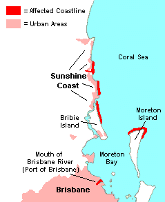
English:
A small, basic map of affected areas in the
en:2009 Queensland oil spill
. Map created by myself using the sunshine coast map as a guide.
|
| Date | 13 March 2009 (original upload date) |
| Source | Transferred from en.wikipedia to Commons by SriMesh . |
| Author | Nick carson at English Wikipedia |
Licensing
|
|
This work has been released into the
public domain
by its author,
Nick carson
at
English Wikipedia
. This applies worldwide.
In some countries this may not be legally possible; if so: Nick carson grants anyone the right to use this work for any purpose , without any conditions, unless such conditions are required by law. |
Original upload log
The original description page was
here
. All following user names refer to en.wikipedia.
- 2009-03-13 09:00 Nick carson 239×293× (11372 bytes) Added Coral Sea text.
- 2009-03-13 08:49 Nick carson 239×293× (11231 bytes) Updated affected area and realigned urban areas.
- 2009-03-13 07:29 Nick carson 239×293× (11234 bytes) Added Port of Brisbane/Brisbane River mouth spill.
- 2009-03-13 07:04 Nick carson 239×293× (10774 bytes) Updated urban areas, more text and arrows.
- 2009-03-13 06:55 Nick carson 239×293× (10409 bytes) A small, basic map of affected areas in the [[2009 Queensland oil spill]]. Map created by myself using the sunshine coast map as a guide.