Quercus_virginiana_range_map_1.png

Size of this preview:
600 × 600 pixels
.
Other resolutions:
240 × 240 pixels
|
480 × 480 pixels
|
768 × 768 pixels
|
1,024 × 1,024 pixels
|
1,800 × 1,800 pixels
.
Summary
| Description |
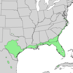
English:
Range map of
Quercus virginiana
— Southern live oak.
|
| Date | |
| Source | Digital representation of "Atlas of United States Trees" by Elbert L. Little, Jr. [1] |
| Author | U.S. Geological Survey |
Licensing
|
|
This image is in the
public domain
in the United States because it only contains materials that originally came from the
United States Geological Survey
, an agency of the
United States Department of the Interior
. For more information, see
the official USGS copyright policy
.
|
|
Original upload log
Transferred from en.wikipedia to Commons by Quadell using CommonsHelper .
The original description page was
here
. All following user names refer to en.wikipedia.
- 2010-05-21 16:34 Masebrock 675×481× (80124 bytes) {{Information |Description=Range map of Quercus virginiana |Source=Digital representation of "Atlas of United States Trees" by Elbert L. Little, Jr. [http://esp.cr.usgs.gov/data/atlas/little/] |Date=1999 |Author=U.S. Geological Survey |Permission={{PD-USG