RFID_antenna_2007.jpg

Size of this preview:
400 × 600 pixels
.
Other resolutions:
160 × 240 pixels
|
320 × 480 pixels
|
512 × 768 pixels
|
1,196 × 1,794 pixels
.
Summary
| Description |
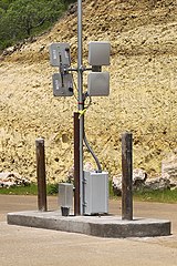
English:
Radio-frequency identification
installation to track vehicles coming into and leaving a gated community. One antenna on each side transmits a signal to activate the passive RFID chip affixed to the vehicle, and the other antenna receives the signal back with the encoded information from the chip. If the chip provides a valid number in the database of the controller located in the box at the base of the pole, the gate is opened.
|
| Date | Taken on 26 June 2007 |
| Source | Own work |
| Author | Larry D. Moore |
|
Permission
( Reusing this file ) |
© 2007 Larry D. Moore. Licensed under
CC BY 4.0
.
Attribution Specification: Reuse without attribution is a violation of the license. The photographer's name and the link to the license are required. A link back to this source is requested. Example: Larry D. Moore, CC BY 4.0 , Wikimedia Commons . |
| Camera location |
|
View this and other nearby images on: OpenStreetMap |
|
|---|
Licensing
Larry D. Moore, the copyright holder of this work, hereby publishes it under the following license:
This file is licensed under the
Creative Commons
Attribution 4.0 International
license.
Attribution:
Larry D. Moore
-
You are free:
- to share – to copy, distribute and transmit the work
- to remix – to adapt the work
-
Under the following conditions:
- attribution – You must give appropriate credit, provide a link to the license, and indicate if changes were made. You may do so in any reasonable manner, but not in any way that suggests the licensor endorses you or your use.