SEUtahStrat.JPG

Size of this preview:
800 × 454 pixels
.
Other resolutions:
320 × 182 pixels
|
640 × 363 pixels
|
1,024 × 581 pixels
|
1,280 × 726 pixels
|
3,161 × 1,794 pixels
.
Summary
| Description |
English:
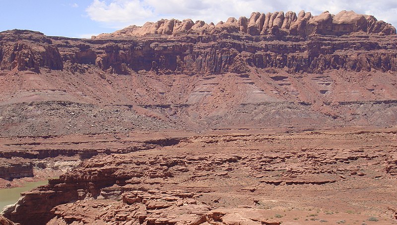
The
Permian
(bottom) through
Jurassic
(top) stratigraphy of the
Colorado Plateau
area of southeastern
Utah
that makes up much of the famous prominent rock formations in protected areas such as
Capitol Reef National Park
and
Canyonlands National Park
.
From top to bottom: Rounded tan domes of the
Navajo Sandstone
, layered red
Kayenta Formation
, cliff-forming, vertically-jointed, red
Wingate Sandstone
, slope-forming, purplish
Chinle Formation
, layered, lighter-red
Moenkopi Formation
, and white, layered
Cutler Formation
sandstone. Picture from
Glen Canyon National Recreation Area
, Utah.
( modified version, 26MAY-2012 , after change on en:Moenkopi Formation ; changing (3) to a (3A,3B), with explanations, because of the larger photo RED debris visible.) The en:Jurassic through en:Permian stratigraphy of the Colorado Plateau area of southeastern Utah that makes up much of the famous prominent rock formations in protected areas such as Capitol Reef National Park and Canyonlands National Park . From top to bottom, ( Jurassic to Permian ): (6)-Rounded tan domes of the Navajo Sandstone , (5)-( very-dark )-layered red Kayenta Formation , (4)-( very-dark )-cliff-forming, vertically-jointed, red Wingate Sandstone , (3B)-( RED debris covered)-slope-forming, purplish Chinle Formation , (3A)-( NO RED Debris )-slope-forming, purplish Chinle Formation , (2)-layered, lighter-red Moenkopi Formation , and (1)-white, layered Cutler Formation sandstone. Picture from Glen Canyon National Recreation Area, Utah.)- (this makes 7 Layers, or there are 6 Layers with 3A, and 3B) |
| Date | (UTC) (Uploaded on Commons at 2011-03-27 17:26:30 (UTC)/Original uploaded at 2010-05-20 16:46:26) |
| Source | I ( Matt Affolter (QFL247) ( talk )) created this work entirely by myself. (Original uploaded on en.wikipedia) |
| Author | Matt Affolter (QFL247) ( talk ) (Transferred by Citypeek /Original uploaded by Matt Affolter (QFL247) ) |
Licensing
Matt Affolter (QFL247)
, the copyright holder of this work, hereby publishes it under the following licenses:
This file is licensed under the
Creative Commons
Attribution-Share Alike 3.0 Unported
license.
Attribution:
Matt Affolter (QFL247)
-
You are free:
- to share – to copy, distribute and transmit the work
- to remix – to adapt the work
-
Under the following conditions:
- attribution – You must give appropriate credit, provide a link to the license, and indicate if changes were made. You may do so in any reasonable manner, but not in any way that suggests the licensor endorses you or your use.
- share alike – If you remix, transform, or build upon the material, you must distribute your contributions under the same or compatible license as the original.

|
Permission is granted to copy, distribute and/or modify this document under the terms of the GNU Free Documentation License , Version 1.2 or any later version published by the Free Software Foundation ; with no Invariant Sections, no Front-Cover Texts, and no Back-Cover Texts. A copy of the license is included in the section entitled GNU Free Documentation License . |
You may select the license of your choice.
Original upload log
The original description page was
here
. All following user names refer to en.wikipedia.
- 2010-05-20 16:46:26 Qfl247 3,161×1,794 (2.5 MB) ({{Information |Description = The [[Permian]] through [[Jurassic]] stratigraphy of the [[Colorado Plateau]] area of southeastern [[Utah]] that makes up much of the famous prominent rock formations in protected areas such as [[Capitol Reef National Park)