SF_Bay_area_USGS.jpg

Size of this preview:
577 × 599 pixels
.
Other resolutions:
231 × 240 pixels
|
462 × 480 pixels
|
770 × 800 pixels
.
| Description |
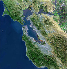
Bay Area Satellite MAP from USGS
Svenska:
Satellitfoto av San Francisco Bay Area.
|
| Source | USGS, please see old version [1] |
| Author | USGS |
![[1]](https://upload.wikimedia.org/wikipedia/commons/archive/d/dc/20060929184646%21SF_Bay_area_USGS.jpg)
|
|
This image is in the
public domain
in the United States because it only contains materials that originally came from the
United States Geological Survey
, an agency of the
United States Department of the Interior
. For more information, see
the official USGS copyright policy
.
|
|