Sagarmatha_National_Park-Gorak_Shep_to_Pheriche_2013-05-06_08-10-23-2013-05-06_08-11-08.jpg
Size of this preview:
800 × 195 pixels
.
Other resolutions:
320 × 78 pixels
|
640 × 156 pixels
|
1,024 × 249 pixels
|
3,287 × 800 pixels
.
Summary
| Description |
English:
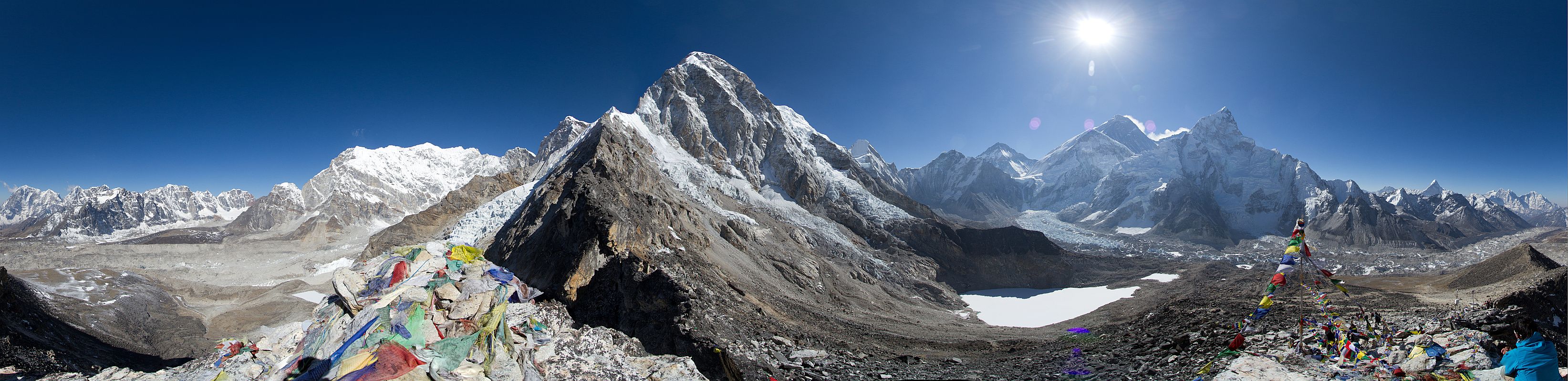
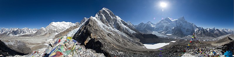
A view from the
Mount Everest Base Camp
(Altitude of 5,364 metres (17,598 ft)) -
Gorak Shep
to
Pheriche
.
नेपाली:
सगरमाथा आधार शिविरवाट देखिएको गोरकशेप देखि फेरिच्चे सम्मको एक मनोरम दृश्य ।
|
||
| Date | |||
| Source | Own work | ||
| Author | Thomas Fuhrmann | ||
| Other versions |

.jpg)
| Camera location |
|
View this and other nearby images on: OpenStreetMap |
|
|---|
Canon Eos 7d, Thomas Fuhrmann, www.snowmanstudios.de
Licensing
I, the copyright holder of this work, hereby publish it under the following license:
This file is licensed under the
Creative Commons
Attribution-Share Alike 3.0 Unported
license.
-
You are free:
- to share – to copy, distribute and transmit the work
- to remix – to adapt the work
-
Under the following conditions:
- attribution – You must give appropriate credit, provide a link to the license, and indicate if changes were made. You may do so in any reasonable manner, but not in any way that suggests the licensor endorses you or your use.
- share alike – If you remix, transform, or build upon the material, you must distribute your contributions under the same or compatible license as the original.
|
|
This image was uploaded as part of
Wiki Loves Earth 2014
.
|

|

|
This image won the 2
nd
prize in the national contest of
Nepal
in
Wiki Loves Earth 2014
Other languages:
|
|
|
This image has been assessed using the
Quality image guidelines
and is considered a
Quality image
.
|
| Annotations | This image is annotated: View the annotations at Commons |