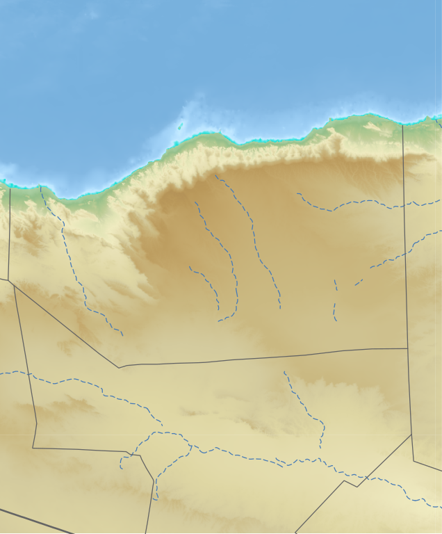
Sanaag_location_relief_map.svg

Size of this PNG preview of this SVG file:
497 × 600 pixels
.
Other resolutions:
199 × 240 pixels
|
398 × 480 pixels
|
636 × 768 pixels
|
848 × 1,024 pixels
|
1,697 × 2,048 pixels
|
609 × 735 pixels
.
erigavo is beautiful town wich located northern of somaliland and is the largest town
Summary
| Description |
English:
Sanaag region in Somaliland/Somalia
日本語:
ソマリア/ソマリランドのサナーグ地域のLocation map用地図
|
| Date | |
| Source | See below |
| Author | See below (Assemblied by User:Freetrashbox ) |
Sources
- Global Relief: ETOPO Global Relief Model / NOAA ( 2022-10-04 ). Ice surface elevation geotiff . Retrieved on 2022-12-13 . / ETOPO_2022_v1_15s_N00W030_surface.tif, ETOPO_2022_v1_15s_N15E030_surface.tif
- International border: GSHHG data version 2.3.7 / NOAA ( 2017-06-15 ). Shoreline / Coastline Resources . Retrieved on 2022-12-13 . / gshhg-shp-2.3.7\WDBII_shp\h\WDBII_border_h_L1.shp
- Intermittent rivers: GSHHG data version 2.3.7 / ibid. / gshhg-shp-2.3.7\WDBII_shp\h\WDBII_river_h_L08.shp
- Regional border of Somaliland: SOMALILAND VULNERABILITY INDEX MAP / Ministry of Planning and National Development of Somaliland. SOMALILAND VULNERABILITY INDEX MAP . Retrieved on 2022-12-13 .
- Regional border of Somalia (without Somaliland): Google map
Design
- Global Relief: Wikipedia:Graphics Lab/Resources/GIS sources and palettes
- International border: R100 G100 B100, 2pts.
- Intermittent rivers: R72 G123 B182, 1pt, dash 5 pts, blank 3pts.
- Regional border of Somaliland: R100 G100 B100, 1pt.
Notes
- The boundaries marked on this map are the borders or region boundaries around this area. Because Somaliland claims the western border of Bari region as the border between Somaliland and Somalia, there is some dispute as to whether this line is a border or a state line.
Licensing
|
|
This image is in the
public domain
because it contains materials that originally came from the U.S.
National Oceanic and Atmospheric Administration
, taken or made as part of an employee's official duties.
|
|