Serranía_del_Empalado.svg

Size of this PNG preview of this SVG file:
618 × 600 pixels
.
Other resolutions:
247 × 240 pixels
|
495 × 480 pixels
|
792 × 768 pixels
|
1,055 × 1,024 pixels
|
2,111 × 2,048 pixels
|
639 × 620 pixels
.
Summary
| Description |
Español:
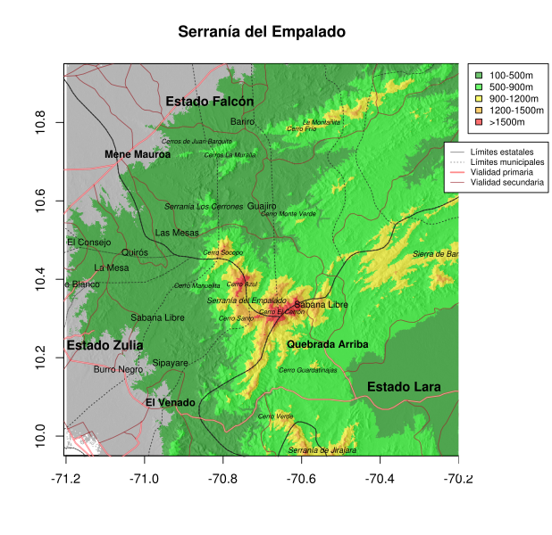
Ubicación de la Serranía del Empalado y el Cerro Socopo en la frontera entre los estados Zulia, Falcón y Lara, en Venezuela. Según el modelo digital de elevación la Serranía del Empalado está separada de la Serranía de Jirajara al sur y la Sierra de Baragua al este por alturas menores a 900 metros. Igualmente, el Cerro Socopo (o Cerro Socopó) está separado del resto de la Serranía del Empalado por la cota de 900m. El área calculada con los contornos de esta cota son: 38,4 km2 para el Cerro Socopo, y 508,3 km2 para el macizo formado por Cerro Azul y El Cerrón.
|
| Date | |
| Source | https://dx.doi.org/10.6084/m9.figshare.1109955 |
| Author | José R. Ferrer-Paris |
| Camera location |
|
View this and other nearby images on: OpenStreetMap |
|
|---|
Licensing
This file is licensed under the
Creative Commons
Attribution 4.0 International
license.
-
You are free:
- to share – to copy, distribute and transmit the work
- to remix – to adapt the work
-
Under the following conditions:
- attribution – You must give appropriate credit, provide a link to the license, and indicate if changes were made. You may do so in any reasonable manner, but not in any way that suggests the licensor endorses you or your use.