Serval_range_IUCN.svg

Size of this PNG preview of this SVG file:
635 × 600 pixels
.
Other resolutions:
254 × 240 pixels
|
508 × 480 pixels
|
813 × 768 pixels
|
1,084 × 1,024 pixels
|
2,169 × 2,048 pixels
|
1,525 × 1,440 pixels
.
Summary
| Description |
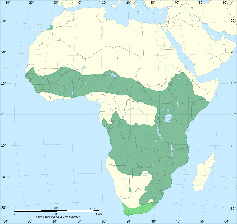
The range of
Leptailurus serval
, based on version sourced from
IUCN Red List
.
|
| Date | (UTC) |
| Source |
This file was derived from: |
| Author |
|

|
|
This is a
retouched picture
, which means that it has been digitally altered from its original version. Modifications:
Redrawn as SVG on better Africa blank
. The original can be viewed here:
Africa map blank.svg
:
|
Licensing
This file is licensed under the
Creative Commons
Attribution-Share Alike 3.0 Unported
license.
-
You are free:
- to share – to copy, distribute and transmit the work
- to remix – to adapt the work
-
Under the following conditions:
- attribution – You must give appropriate credit, provide a link to the license, and indicate if changes were made. You may do so in any reasonable manner, but not in any way that suggests the licensor endorses you or your use.
- share alike – If you remix, transform, or build upon the material, you must distribute your contributions under the same or compatible license as the original.
Original upload log
This image is a derivative work of the following images:
-
File:Serval_range.png
licensed with Cc-by-sa-2.5,2.0,1.0, Cc-by-sa-3.0-migrated, GFDL
- 2012-02-28T21:17:32Z Izvora 606x649 (28279 Bytes) Source http://maps.iucnredlist.org/map.html?id=11638
- 2011-12-27T11:18:12Z Schneelocke 907x955 (40507 Bytes) New map is unusable for colorblind readers. See talk page.
- 2011-07-19T02:07:48Z Craig Pemberton 344x372 (14385 Bytes) Normalize with other range maps in preparation for composite maps of higher taxa.
- 2005-12-09T22:49:27Z Laurascudder 907x955 (40507 Bytes) The range of [[leptailurus serval]]. Started from [[w: User:Brion VIBBER/Maps and images for Wikipedia|Brion VIBBER]]'s maps using information from [http://wildcat.cat-city.com/serval/map-serv.gif], [http://www.wildcatconser
-
File:Africa_map_blank.svg
licensed with Cc-by-sa-2.5,2.0,1.0, Cc-by-sa-3.0-migrated, GFDL
- 2011-07-14T19:50:24Z Sting 1525x1440 (698781 Bytes) Sudan/South Sudan 2011-07 border update
- 2009-01-10T20:36:44Z Sting 1525x1440 (710059 Bytes) Detail correction
- 2008-06-27T03:34:58Z Sting 1525x1440 (711453 Bytes) Completely new drawing with known projection
- 2006-05-31T15:28:42Z Sting 1390x1295 (571519 Bytes) Enhanced version : African and Asian continents separated
- 2006-05-31T03:53:32Z Sting 1390x1295 (566642 Bytes) {{Information |Description=Blank vector graphic map of [[:Category:Maps of Africa|Africa]] |Source=Several bitmap-type maps |Date= May 2006 |Author= Eric Gaba ([[User:Sting|Sting]]) |Permission=GFDL or CC-BY-SA |other_version
Uploaded with derivativeFX