South_Lodge_,_Streatlam_Park_-_geograph.org.uk_-_201479.jpg
No higher resolution available.
Summary
| Description |
English:
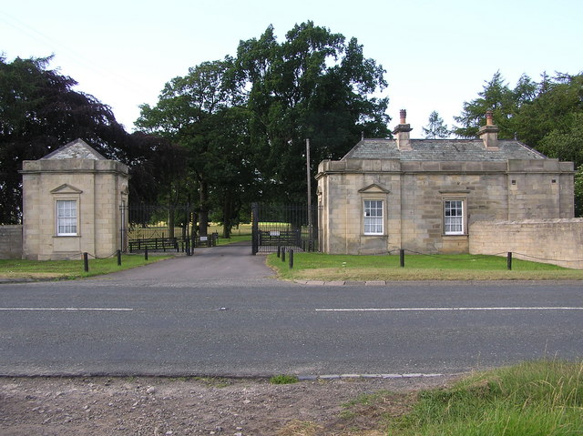
South Lodge : Streatlam Park. On the A688. The site of Streatlam Castle a Mansion built by Sir William Bowes about 1718 on the site of the 15th century Castle. Demolished in 1927, and the remains (of the original castle) blown up by the Army in 1956.
|
| Date | |
| Source | From geograph.org.uk |
| Author | Hugh Mortimer |
|
Attribution
( required by the license ) |
Hugh Mortimer / South Lodge : Streatlam Park / |
| Camera location |
|
View this and other nearby images on: OpenStreetMap |
|
|---|
_region:GB-GBN_heading:0.00&language=en)
| Object location |
|
View this and other nearby images on: OpenStreetMap |
|
|---|
_region:GB-GBN_heading:0.00&language=en)
Licensing

|
This image was taken from the
Geograph project
collection. See
this photograph's page
on the Geograph website for the photographer's contact details. The copyright on this image is owned by
Hugh Mortimer
and is licensed for reuse under the
Creative Commons
Attribution-ShareAlike 2.0 license.
|
This file is licensed under the
Creative Commons
Attribution-Share Alike 2.0 Generic
license.
Attribution:
Hugh Mortimer
-
You are free:
- to share – to copy, distribute and transmit the work
- to remix – to adapt the work
-
Under the following conditions:
- attribution – You must give appropriate credit, provide a link to the license, and indicate if changes were made. You may do so in any reasonable manner, but not in any way that suggests the licensor endorses you or your use.
- share alike – If you remix, transform, or build upon the material, you must distribute your contributions under the same or compatible license as the original.
- Remove redundant categories and try to put this image in the most specific category/categories
- Remove this template
- The location categories are based on information from this geonames tool and this OpenStreetMap tool combined with a database. You can also have a look at this tool from mysociety .
- The topic category from Geograph was Lodge (find similar images at Geograph )