Spanish-Arabic_map_of_1109.jpg
Summary
| Description |
English:
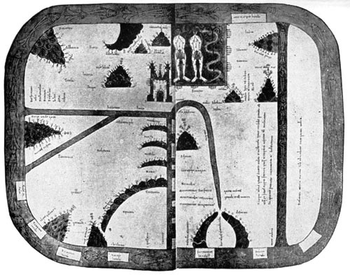
Spanish-Arabic map of 1109
(B. Mus., Add. mss., 11695). The original, gorgeously coloured, represents the crudest of Christian and Moslem notions of the world. Even more crude than in the Turin map and the Mappe-Monde of St. Sever, both of which offer some resemblances to this. The earth is represented as of quadrangular shape, surrounded by the ocean. At the E. is Paradise with the figures of the Temptation. A part of the S. is cut off by the Red Sea, which is straight (and coloured red), just as the straight Mediterranean, with its quadrangular islands, divides the N.W. quarter, or Europe, from the S.W. quarter, or Africa. The Ægean Sea joins the Mediterranean at a right angle, in the centre of the map. In the ocean, bordering the whole, are square islands, e.g., Tile (Thule), Britania, Scocia, Fu(o)rtunarum insula. The Turin map occurs in another copy of the same work—A Commentary on the Apocalypse. (Source: http://www.gutenberg.org/files/18757/18757-h/ ) |
| Date | |
| Source | http://www.gutenberg.org/files/18757/18757-h/images/map06.jpg |
| Author | Unknown author |
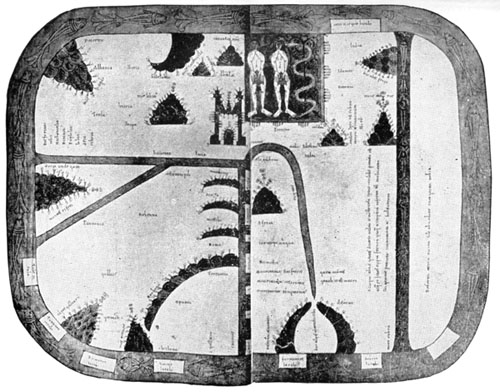
T-O map with the earthly Garden of Eden at the top
Summary
|
|
This work is in the public domain in its country of origin and other countries and areas where the copyright term is the author's life plus 100 years or fewer . |
| This file has been identified as being free of known restrictions under copyright law, including all related and neighboring rights. | |