Spreading_ridges_volcanoes_map-en.svg

Size of this PNG preview of this SVG file:
800 × 402 pixels
.
Other resolutions:
320 × 161 pixels
|
640 × 322 pixels
|
1,024 × 515 pixels
|
1,280 × 643 pixels
|
2,560 × 1,286 pixels
|
4,995 × 2,510 pixels
.
Summary
| Description |
English:
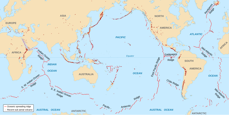
World map in English showing the divergent plate boundaries (OSR – Oceanic Spreading Ridges) and recent sub aerial volcanoes.
Français :
Carte en anglais des dorsales océaniques et volcans terrestres récents.
|
||
| Date | 2006-10, upgraded 2015-09 | ||
| Source |
|
||
| Author | Eric Gaba ( Sting - fr:Sting ) | ||
|
Permission
( Reusing this file ) |
|
||
| Other versions |
|

The Data source link above is now dead. Potentially active/active volcanoes appear to have been mapped if erupted within about last 10,000 odd years with an accuracy of about 50 km (31 mi) onto current basemap. Some active volcanoes are not shown and divergent plate boundaries may have inaccuracies. The map has not been updated since 2015.
Licensing
I, the copyright holder of this work, hereby publish it under the following license:
This file is licensed under the
Creative Commons
Attribution-Share Alike 2.5 Generic
license.
-
You are free:
- to share – to copy, distribute and transmit the work
- to remix – to adapt the work
-
Under the following conditions:
- attribution – You must give appropriate credit, provide a link to the license, and indicate if changes were made. You may do so in any reasonable manner, but not in any way that suggests the licensor endorses you or your use.
- share alike – If you remix, transform, or build upon the material, you must distribute your contributions under the same or compatible license as the original.