St.Crallo's_Church_Coychurch_-_geograph.org.uk_-_337153.jpg
No higher resolution available.
|
|
This is a photo of
listed building
number
11252
.
|
Summary
| Description |
English:
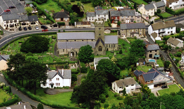
St.Crallo's Church Coychurch The Welsh name for the Village of Coychurch is Llangrallo. Obviously, named after St.Crallo. The white house, bottom left is the Rectory now used as the Llandaff Diocesan Office. The two houses, bottom right, are built on the site of a 7th Century Collegiate. The Church is of the 12th Century.
|
| Date | |
| Source | From geograph.org.uk |
| Author | kenneth rees |
|
Attribution
( required by the license ) |
kenneth rees / St.Crallo's Church Coychurch / |
| Camera location |
|
View this and other nearby images on: OpenStreetMap |
|
|---|
_heading:337.00&language=en)
| Object location |
|
View this and other nearby images on: OpenStreetMap |
|
|---|
_heading:337.00&language=en)
Licensing

|
This image was taken from the
Geograph project
collection. See
this photograph's page
on the Geograph website for the photographer's contact details. The copyright on this image is owned by
kenneth rees
and is licensed for reuse under the
Creative Commons
Attribution-ShareAlike 2.0 license.
|
This file is licensed under the
Creative Commons
Attribution-Share Alike 2.0 Generic
license.
Attribution:
kenneth rees
-
You are free:
- to share – to copy, distribute and transmit the work
- to remix – to adapt the work
-
Under the following conditions:
- attribution – You must give appropriate credit, provide a link to the license, and indicate if changes were made. You may do so in any reasonable manner, but not in any way that suggests the licensor endorses you or your use.
- share alike – If you remix, transform, or build upon the material, you must distribute your contributions under the same or compatible license as the original.