St_Joseph_Michigan_aerial_view.jpg

Size of this preview:
800 × 558 pixels
.
Other resolutions:
320 × 223 pixels
|
640 × 447 pixels
|
1,024 × 715 pixels
|
1,280 × 893 pixels
|
1,500 × 1,047 pixels
.
|
|
This is an image of a place or building that is listed on the
National Register of Historic Places
in the
United States of America
. Its reference number is
5001211
.
|
| Description |
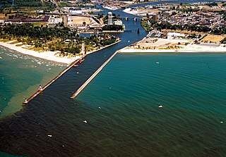
English:
The shore and river outlet at St. Joseph, Michigan, USA. The St. Joseph River flows into Lake Michigan through the city of the same name.
|
|||
| Date | not specified or unknown; predates 2000 | |||
| Source |
U.S. Army Corps of Engineers Digital Visual Library
Image page : Archive link Image description page : Archive link Digital Visual Library home page |
|||
| Author | U.S. Army Corps of Engineers, photographer not specified or unknown | |||
|
Permission
( Reusing this file ) |
|
|||
| Location | St. Joseph, Berrien County, Michigan, USA |
| Camera location |
|
View this and other nearby images on: OpenStreetMap |
|
|---|

