Stromboli_Eruption_Crop1.png


Summary

Description

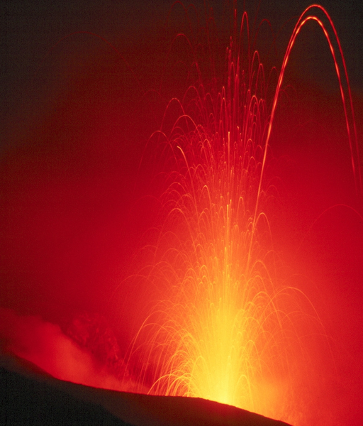
Stromboli Eruption 100 m (Isole Eolie/Italia)

  • English: Eruption of Stromboli (Isole Eolie/Italia), ca. 100m (300ft) vertically. Exposure of several seconds. The dashed trajectories are the result of lava pieces with a bright hot side and a cool dark side rotating in mid-air.
  • Deutsch: Etwa 100m hohe Eruption des (Isole Eolie, Italien). Aufgenommen mit einer Belichtungszeit von mehreren Sekunden. Die gestrichelten Flugbahnen entstehen, wenn Lavabrocken mit einer heißeren und damit helleren Seite und einer kühleren dunkleren während des Fluges rotieren.
Date photo taken in 1980, cropped 2007-06-08
Source Photo taken by and cropped by User:Gralo
Author Photo taken by de:Benutzer:Wolfgangbeyer and cropped by User:Gralo
Permission
( Reusing this file )
GFDL
Other versions Original image Image:Stromboli Eruption.jpg
Camera location 38° 48′ 16″ N, 15° 12′ 34″ E Kartographer map based on OpenStreetMap. View this and other nearby images on: OpenStreetMap info

Licensing

GNU head Permission is granted to copy, distribute and/or modify this document under the terms of the GNU Free Documentation License , Version 1.2 or any later version published by the Free Software Foundation ; with no Invariant Sections, no Front-Cover Texts, and no Back-Cover Texts. A copy of the license is included in the section entitled GNU Free Documentation License .
w:en:Creative Commons
attribution share alike
This file is licensed under the Creative Commons Attribution-Share Alike 3.0 Unported license.
You are free:
  • to share – to copy, distribute and transmit the work
  • to remix – to adapt the work
Under the following conditions:
  • attribution – You must give appropriate credit, provide a link to the license, and indicate if changes were made. You may do so in any reasonable manner, but not in any way that suggests the licensor endorses you or your use.
  • share alike – If you remix, transform, or build upon the material, you must distribute your contributions under the same or compatible license as the original.
This licensing tag was added to this file as part of the GFDL licensing update .

Captions

Add a one-line explanation of what this file represents

Items portrayed in this file

depicts

38°48'15.998"N, 15°12'33.998"E