Swedish_Empire_in_the_Baltic_(1560-1721).png
No higher resolution available.
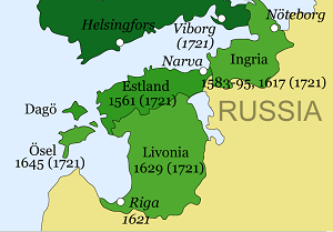
| Description | Map showing the development of the Swedish Empire in the Baltic, 1550-1721, the time of the Truce of Plussa through to the Treaty of Nystad. |
| Date | (UTC) |
| Source | |
| Author |
|
.png)
_blank.svg)
I, the copyright holder of this work, hereby publish it under the following licenses:
This file is licensed under the
Creative Commons
Attribution 3.0 Unported
license.
-
You are free:
- to share – to copy, distribute and transmit the work
- to remix – to adapt the work
-
Under the following conditions:
- attribution – You must give appropriate credit, provide a link to the license, and indicate if changes were made. You may do so in any reasonable manner, but not in any way that suggests the licensor endorses you or your use.

|
Permission is granted to copy, distribute and/or modify this document under the terms of the GNU Free Documentation License , Version 1.2 or any later version published by the Free Software Foundation ; with no Invariant Sections, no Front-Cover Texts, and no Back-Cover Texts. A copy of the license is included in the section entitled GNU Free Documentation License . |
You may select the license of your choice.
Original upload log
This image is a derivative work of the following images:
-
File:Swedish_Empire_in_Early_Modern_Europe_(1560-1815).png
licensed with Cc-by-3.0, GFDL
- 2011-01-30T10:04:27Z Hayden120 1802x2213 (418158 Bytes) Corrected date for Karl X Gustav's reign.
- 2009-12-05T12:36:33Z M.K. 1802x2213 (696240 Bytes) {{Information |Description=Map showing the development of the Swedish Empire in Early Mordern Europe (1560-1815) |Source=*[[:File:Ortus-imperii-suecorum.png|Ortus-imperii-suecorum.png]] *[[:File:Swedish Empire in Early Morder
Uploaded with derivativeFX