Tarfala_valley_panorama.jpg

Size of this preview:
800 × 267 pixels
.
Other resolutions:
320 × 107 pixels
|
640 × 213 pixels
|
1,024 × 341 pixels
|
1,280 × 427 pixels
|
2,560 × 853 pixels
|
7,188 × 2,396 pixels
.
Summary
| Description |
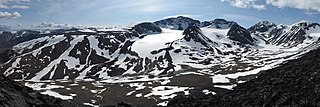
English:
Tarfala valley panorama with Kebnekaise, glaciers, and research station
Français :
Panorama de la vallée de Tarfala, où est située la station de recherche scientifique de Tarfala. Le
Kebnekaise
, point culminant de la Suède (2 111 m), se trouve au centre de l'image.
සිංහල:
ටර්ෆාලා නිම්නයේ දර්ශණයක්
|
| Date | |
| Source | Own work |
| Author | Alexandar Vujadinovic |
| Other versions |


|
| Camera location |
|
View this and other nearby images on: OpenStreetMap |
|
|---|
|
|
|
This image was selected as
picture of the day
on Wikimedia Commons for
13 October 2014
. It was captioned as follows:
English:
Overview of
Tarfala Valley
, where the
Tarfala research station
is located.
Kebnekaise
, Sweden's highest mountain, is in the center of the image.
Other languages:
Bosanski
:
Pogled na dolinu
Tarfala
, gdje se nalazi
istoimena istraživačka stanica
. Najviša planina u Švedskoj,
Kebnekaise
, je u centru slike.
Čeština
:
Panorama údolí
Tarfala Valley
s přírodovědeckou stanicí Tarfala research station. Uprostřed snímku nejvyšší
švédská
hora
Kebnekaise
.
English
:
Overview of
Tarfala Valley
, where the
Tarfala research station
is located.
Kebnekaise
, Sweden's highest mountain, is in the center of the image.
Français
:
Panorama de la vallée de Tarfala, où est située la station de recherche scientifique de Tarfala. Le
Kebnekaise
, point culminant de la Suède (2 111 m), se trouve au centre de l'image.
Italiano
:
Panorama della valle di Tarfala, sede di una stazione di ricerca climatica dell'
Università di Stoccolma
. Al centro dell'immagine c'è la più alta montagna della Svezia, il
Kebnekaise
.
Nederlands
:
Overzicht van de
Tarfalavallei
, waar het Tarfala onderzoeksstation zich bevindt. In het midden van de foto de
Kebnekaise
, de hoogste berg van Zweden.
|

|
This image has been assessed under the valued image criteria and is considered the most valued image on Commons within the scope: Tarfala . You can see its nomination here . |
Licensing
I, the copyright holder of this work, hereby publish it under the following license:
This file is licensed under the
Creative Commons
Attribution-Share Alike 3.0 Unported
license.
-
You are free:
- to share – to copy, distribute and transmit the work
- to remix – to adapt the work
-
Under the following conditions:
- attribution – You must give appropriate credit, provide a link to the license, and indicate if changes were made. You may do so in any reasonable manner, but not in any way that suggests the licensor endorses you or your use.
- share alike – If you remix, transform, or build upon the material, you must distribute your contributions under the same or compatible license as the original.