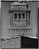
Telephoto_view_of_south_elevation_of_pedestal._February_1984._-_Statue_of_Liberty,_Liberty_Island,_Manhattan,_New_York,_New_York_County,_NY_HAER_NY,31-NEYO,89-18_(cropped).tif

Size of this JPG preview of this TIF file:
576 × 599 pixels
.
Other resolutions:
231 × 240 pixels
|
461 × 480 pixels
|
738 × 768 pixels
|
984 × 1,024 pixels
|
1,968 × 2,048 pixels
|
3,215 × 3,345 pixels
.
Summary
| Telephoto view of south elevation of pedestal. February 1984. - Statue of Liberty, Liberty Island, Manhattan, New York, New York County, NY | ||||
|---|---|---|---|---|
| Photographer |
Lowe, Jet, creator
|
|||
| Title |
Telephoto view of south elevation of pedestal. February 1984. - Statue of Liberty, Liberty Island, Manhattan, New York, New York County, NY
|
|||
| Depicted place | New York; New York County; New York | |||
| Date | 1984 | |||
| Dimensions | 4 x 5 in. | |||
| Current location |
Library of Congress Prints and Photographs Division Washington, D.C. 20540 USA
http://hdl.loc.gov/loc.pnp/pp.print
|
|||
| Accession number |
HAER NY,31-NEYO,89-18
|
|||
| Credit line |
|
|||
| Source | https://www.loc.gov/pictures/item/ny1251.photos.120276p | |||
|
Permission
( Reusing this file ) |
|
|||
| Other versions | ||||
