The_Blaen-y-cwm_mill_from_the_internal_tramway_leading_to_the_top_of_the_Blaen-y-Cwm_pit._-_geograph.org.uk_-_596449.jpg
No higher resolution available.
Summary
| Description |
English:
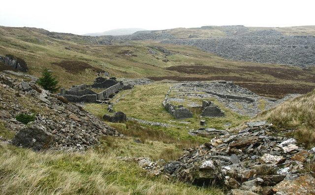
The Blaen-y-cwm mill from the internal tramway leading to the top of the Blaen-y-Cwm pit. This tramway was linked to the floor of the pit by an uphauling incline. Quarried rock from the pit (and prior to the untopping from the underground workings) was transported along the tramway to the Blaen-y-Cwm exit incline and down hauled to the mill.Finished slate would then be uphauled to the Rhiwbach Tramroad.
|
| Date | |
| Source | From geograph.org.uk |
| Author | Eric Jones |
|
Attribution
( required by the license ) |
Eric Jones / The Blaen-y-cwm mill from the internal tramway leading to the top of the Blaen-y-Cwm pit. / |
| Camera location |
|
View this and other nearby images on: OpenStreetMap |
|
|---|
_heading:337.00&language=en)
| Object location |
|
View this and other nearby images on: OpenStreetMap |
|
|---|
_heading:337.00&language=en)
Licensing

|
This image was taken from the
Geograph project
collection. See
this photograph's page
on the Geograph website for the photographer's contact details. The copyright on this image is owned by
Eric Jones
and is licensed for reuse under the
Creative Commons
Attribution-ShareAlike 2.0 license.
|
This file is licensed under the
Creative Commons
Attribution-Share Alike 2.0 Generic
license.
Attribution:
Eric Jones
-
You are free:
- to share – to copy, distribute and transmit the work
- to remix – to adapt the work
-
Under the following conditions:
- attribution – You must give appropriate credit, provide a link to the license, and indicate if changes were made. You may do so in any reasonable manner, but not in any way that suggests the licensor endorses you or your use.
- share alike – If you remix, transform, or build upon the material, you must distribute your contributions under the same or compatible license as the original.