The_USS_Arizona_(BB-39)_burning_after_the_Japanese_attack_on_Pearl_Harbor_-_NARA_195617_-_Edit.jpg
Size of this preview:
758 × 600 pixels
.
Other resolutions:
303 × 240 pixels
|
607 × 480 pixels
|
971 × 768 pixels
|
1,280 × 1,013 pixels
|
2,560 × 2,025 pixels
|
2,940 × 2,326 pixels
.
|
|
This is an image of a place or building that is listed on the
National Register of Historic Places
in the
United States of America
. Its reference number is
89001083
.
|
|
Summary
| Description |
English:
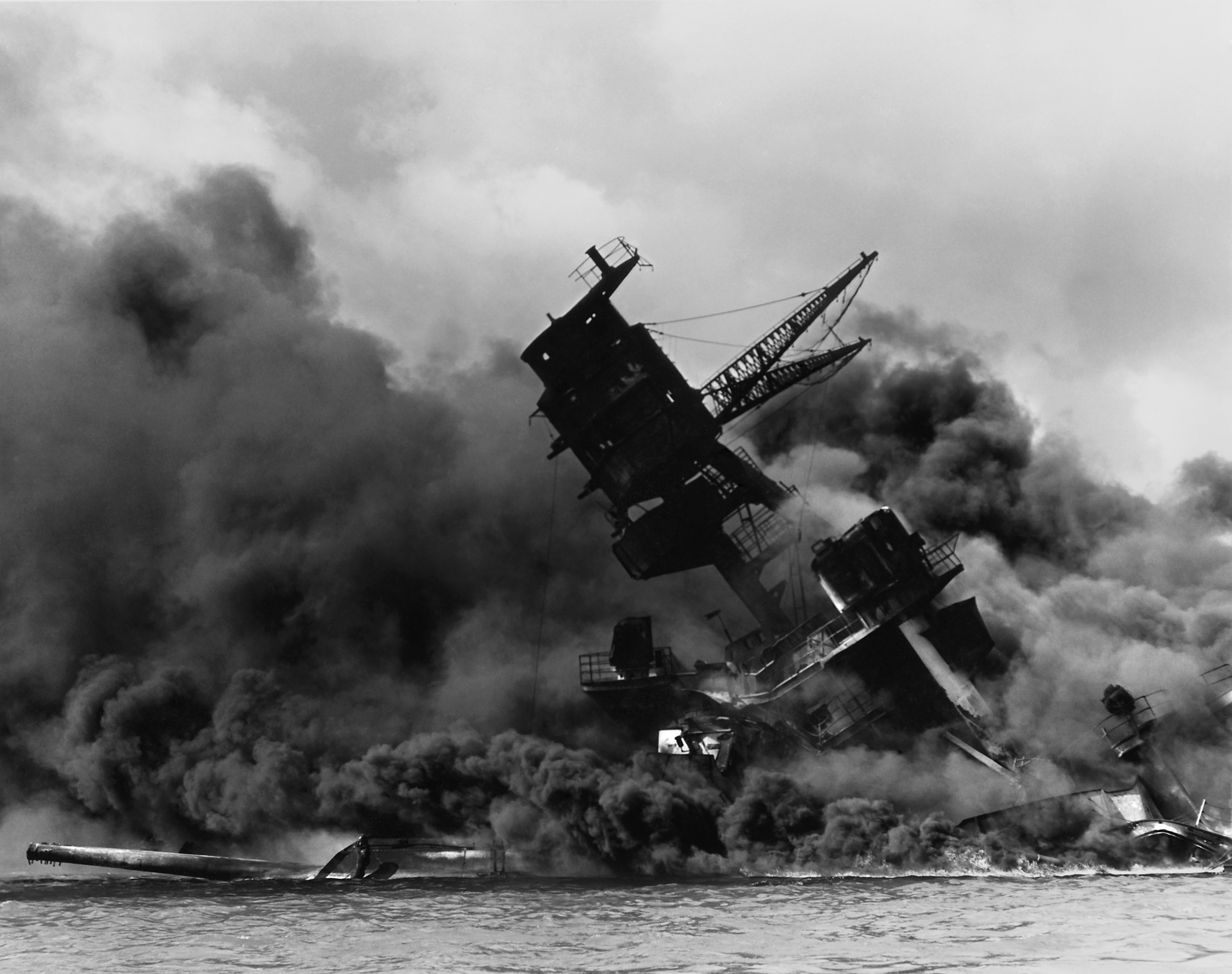
The USS Arizona (BB-39) burning after the Japanese attack on Pearl Harbor, 7 December 1941. USS
Arizona
sunk at
en:Pearl Harbor
. The ship is resting on the harbor bottom. The supporting structure of the forward tripod mast has collapsed after the forward magazine exploded.
Português:
O USS Arizona (BB-39) em chamas após o ataque japonês no Pearl Harbor, dia 7 de dezembro de 1941. USS
Arizona
. Os restos do navio está no fundo do Pearl Harbor. A estrutura que suporta o tripé frontral do mastro entrou em colapso apos a frente explodir.
Deutsch:
Die USS Arizona (BB-39) brennt nach dem japanischen Angriff auf Pearl Harbor, 7.12.1941
|
|||||
| Date | ||||||
| Source |
|
|||||
| Author |
|
|||||
|
Permission
( Reusing this file ) |
|
|||||
| Other versions |
|


_burning_after_the_Japanese_attack_on_Pearl_Harbor_-_NARA_-_195617.jpg)


| Object location |
|
View this and other nearby images on: OpenStreetMap |
|
|---|
_burning_after_the_Japanese_attack_on_Pearl_Harbor_-_NARA_195617_-_Edit.jpg¶ms=021.367778_N_-157.952778_E_globe:Earth_class:object_region:US_type:landmark_scale:1500_&language=en)
Licensing
|
|
This file was provided to Wikimedia Commons by the
National Archives and Records Administration
as part of a
cooperation project
. The National Archives and Records Administration provides images depicting American and global history which are public domain or licensed under a free license.
|
|
|
This work is in the
public domain
in the United States because it is a
work prepared by an officer or employee of the United States Government as part of that person’s official duties
under the terms of
Title 17, Chapter 1, Section 105
of the
US Code
.
Note
: This only applies to original works of the Federal Government and not to the work of any individual
U.S. state
,
territory
, commonwealth, county, municipality, or any other subdivision. This template also does not apply to postage stamp designs published by the
United States Postal Service
since 1978
. (See §
313.6(C)(1)
of Compendium of U.S. Copyright Office Practices). It also does not apply to certain US coins; see
The US Mint Terms of Use
.
|

|
| This file has been identified as being free of known restrictions under copyright law, including all related and neighboring rights. | ||