The_shrinking_Southern_Ocean.png

Size of this preview:
800 × 400 pixels
.
Other resolutions:
320 × 160 pixels
|
640 × 320 pixels
|
1,024 × 512 pixels
|
1,280 × 640 pixels
|
2,560 × 1,280 pixels
|
15,000 × 7,500 pixels
.
Summary
| Warning | The original file is very high-resolution. It might not load properly or could cause your browser to freeze when opened at full size. |
|---|
| Description |
English:
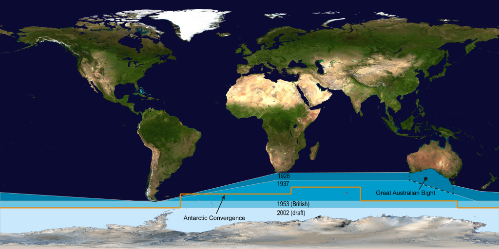
Satellite map showing how the delineation of the Southern Ocean has been moving southwards since the original formal delineation of the ocean in 1928 through to the (draft) delineation by the IHO in 2002.
|
| Date | |
| Source | Own work |
| Author | Cruickshanks |
This map has been derived from the public domain NASA image here File:Whole world - land and oceans.jpg
Licensing
I, the copyright holder of this work, hereby publish it under the following license:
This file is licensed under the
Creative Commons
Attribution-Share Alike 3.0 Unported
license.
-
You are free:
- to share – to copy, distribute and transmit the work
- to remix – to adapt the work
-
Under the following conditions:
- attribution – You must give appropriate credit, provide a link to the license, and indicate if changes were made. You may do so in any reasonable manner, but not in any way that suggests the licensor endorses you or your use.
- share alike – If you remix, transform, or build upon the material, you must distribute your contributions under the same or compatible license as the original.