Thrown_fault_blocks.jpg
No higher resolution available.
| Description |
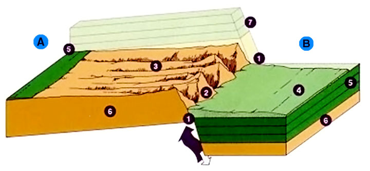
Schematic diagram of geological fault with thrown blocks. 1 Teton Fault Zone 2 Steep eastern face 3 Gentle western slope 4 Valley floors filled with sediments of cobbles, gravel, and sand 5 Sedimentary rock layers 6 Bedrock 7 Sedimentary rock layers now worn away; these matched layers 5 |
| Date | (UTC) |
| Source |
|
| Author |
|
|
|
This is a
retouched picture
, which means that it has been digitally altered from its original version. Modifications:
enlarge and make generic and international
. The original can be viewed here:
Teton fault block.jpg
:
|
|
|
This image or media file contains material based on a work of a National Park Service employee, created as part of that person's official duties. As a work of the U.S. federal government , such work is in the public domain in the United States. See the NPS website and NPS copyright policy for more information. |
|
Original upload log
This image is a derivative work of the following images:
-
File:Teton_fault_block.jpg
licensed with PD-USGov-NPS
- 2009-01-14T13:56:38Z File Upload Bot (Magnus Manske) 400x254 (26702 Bytes) {{BotMoveToCommons|en.wikipedia}} {{Information |Description={{en|NPS image from http://www2.nature.nps.gov/geology/parks/grte/}} |Source=Transferred from [http://en.wikipedia.org en.wikipedia]; transferred to Commons by [[U
Uploaded with derivativeFX
| Annotations | This image is annotated: View the annotations at Commons |