Trade_union_density_rate_map.svg

Size of this PNG preview of this SVG file:
800 × 406 pixels
.
Other resolutions:
320 × 162 pixels
|
640 × 325 pixels
|
1,024 × 520 pixels
|
1,280 × 650 pixels
|
2,560 × 1,300 pixels
|
2,754 × 1,398 pixels
.
Summary
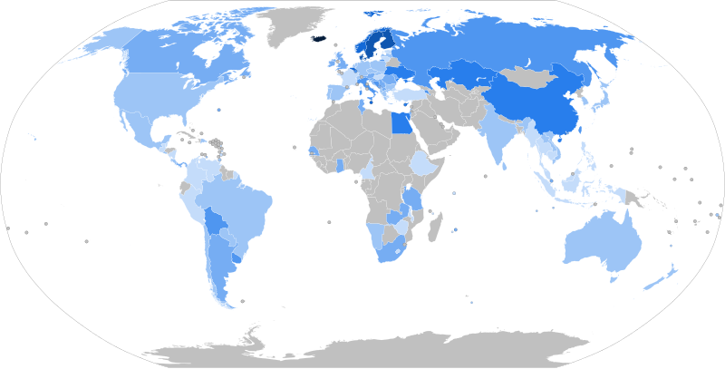
| Description |
English:
World map with countries shaded according to their
trade union
density rate with statistics provided by the
International Labour Organization
Department of Statistics
90.0–99.
9
%
80.0–89.
9
%
70.0–79.
9
%
60.0–69.
9
%
50.0–59.
9
%
40.0–49.
9
%
30.0–39.
9
%
20.0–29.
9
%
10.0–19.
9
%
0.0–9.
9
%
No data
|
| Date | |
| Source |
Map derived from
BlankMap-World.svg
Data retrieved from the International Labour Organization (as of 17 April 2022) |
| Author | JayCoop |
| SVG development |
This
map
was created with a
text editor
.
|


|
This file may be updated to reflect new information.
If you wish to use a specific version of the file without new updates being mirrored, please upload the required version as a separate file. |
Licensing
I, the copyright holder of this work, hereby publish it under the following license:
|
|
This file is made available under the Creative Commons CC0 1.0 Universal Public Domain Dedication . |
|
The person who associated a work with this deed has dedicated the work to the
public domain
by waiving all of their rights to the work worldwide under copyright law, including all related and neighboring rights, to the extent allowed by law. You can copy, modify, distribute and perform the work, even for commercial purposes, all without asking permission.
|