Tuhala_Witches_Well2_21-03-2013.jpg

Size of this preview:
397 × 599 pixels
.
Other resolutions:
159 × 240 pixels
|
318 × 480 pixels
|
509 × 768 pixels
|
679 × 1,024 pixels
|
1,357 × 2,048 pixels
|
3,314 × 5,000 pixels
.
Summary
| Description |
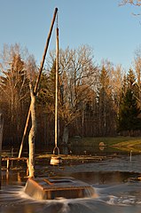
Eesti:
Tuhala nõiakaev "keemas". Kaev on ajutine karstiallikas Tuhala maastikukaitsealal Tuhala karstiala läbival maa-alusel jõel.
English:
Witch's Well (karst spring) in Tuhala (Estonia) is "boiling over". Water erupts for only a short period of time and not every year. It starts to come out from the well when excess water from the Mahtra swamp fills up the underground river and the overflowing river water seeks an escape through the well. According to local legend, the well boils over when the witches of Tuhala make a sauna below the ground and beat each other with birch branches, causing a commotion on the surface.
Deutsch:
"Hexenbrunnen von Tuhala" (Estland). Wasser bricht aus dem Karstquelle nur für einen kurzen Zeitraum und nicht jedes Jahr. Nach heftigem Regen oder während der Schneeschmelze kommt es (meist im Frühling) zu einem Naturschauspiel: bei starkem Anschwellen des Flusses Tuhala, der hier unterirdisch verläuft, treten bis zu 100 Liter Wasser pro Sekunde aus dem Brunnen heraus.
Русский:
"Вскипающий" Ведьмин колодец в Тухале (Эстония). Это явление происходит во время весеннего половодья, когда расход воды через подземную реку Тухала резко возрастает и она затапливает карстовые полости, над которыми находится колодец. Уровень воды в колодце поднимается, и происходит самоизлив. Согласно преданию "Ведьмин колодец" закипает, когда тухалаские ведьмы в нем парятся.
|
| Date | |
| Source | Own work |
| Author | Ivar Leidus |
| Camera location |
|
View this and other nearby images on: OpenStreetMap |
|
|---|
Licensing
I, the copyright holder of this work, hereby publish it under the following license:
This file is licensed under the
Creative Commons
Attribution-Share Alike 3.0 Unported
license.
-
You are free:
- to share – to copy, distribute and transmit the work
- to remix – to adapt the work
-
Under the following conditions:
- attribution – You must give appropriate credit, provide a link to the license, and indicate if changes were made. You may do so in any reasonable manner, but not in any way that suggests the licensor endorses you or your use.
- share alike – If you remix, transform, or build upon the material, you must distribute your contributions under the same or compatible license as the original.
|
|
This image has been assessed using the
Quality image guidelines
and is considered a
Quality image
.
|