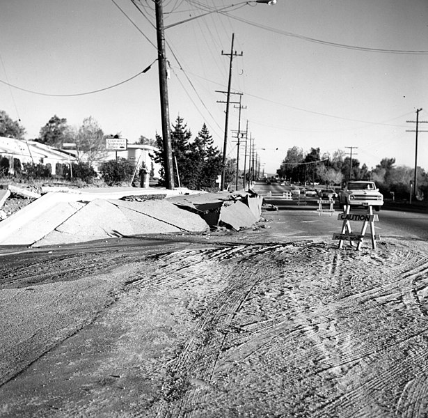
USGS_-_1971_San_Fernando_earthquake_-_Scarp_at_Foothill_Nursing_Home_-_Street_level_view.jpg

Size of this preview:
615 × 600 pixels
.
Other resolutions:
246 × 240 pixels
|
492 × 480 pixels
|
788 × 768 pixels
|
1,050 × 1,024 pixels
|
1,400 × 1,365 pixels
.
Summary
| Description |
English:
San Fernando Earthquake, February 9, 1971, 6:01am PST. [Location centered at 34 degrees 24.67 minutes north, 118 degrees 24.04 west. Magnitude 6.6. Depth 8.4 km. The total surface rupture was roughly 19 km long with a maximum slip of 2 meters. Also known as the Sylmar Earthquake. This earthquake caused $500 million in property damage and 65 deaths, most deaths occurred at the Veteran's Administration Hospital.] Scarp in front of Foothill Nursing Home on Foothill Blvd, near Vaughn Street. The Nursing Home pictured was extensively damaged during the quake. View towards southeast. Feb 11, 1971.
|
| Date | |
| Source | [1] |
| Author | USGS (Wallace, R.E.) |
Licensing
|
|
This image is in the
public domain
in the United States because it only contains materials that originally came from the
United States Geological Survey
, an agency of the
United States Department of the Interior
. For more information, see
the official USGS copyright policy
.
|
|