US_Catholic_Dioceses_and_Names.png

Size of this preview:
800 × 427 pixels
.
Other resolutions:
320 × 171 pixels
|
640 × 342 pixels
|
1,024 × 547 pixels
|
1,280 × 684 pixels
|
2,560 × 1,368 pixels
|
5,978 × 3,194 pixels
.
Summary
| Description |
English:
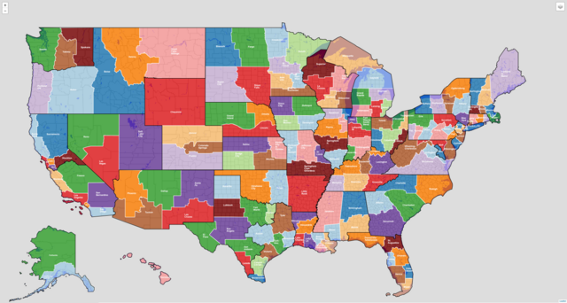
This is a map of all Catholic Latin-Rite dioceses in the United States. I created the map using Python and geojson.io. I used OpenStreetMap and Wikipedia data to revise diocese boundaries and plot cathedral locations. (If this use of OpenStreetMap and Wikipedia data requires that I publish the map under the CC-BY-SA license instead of the CC-BY license, please let me know.)
White lines are diocesan boundaries; black lines are provincial boundaries; and diocese names are in white text. An interactive version of this map can be found here: https://kburchfiel.github.io/us_diocese_mapper/revised_diocese_map.html The project's GitHub page can be found here: https://github.com/kburchfiel/us_diocese_mapper |
| Date | |
| Source | Own work |
| Author | Kenneth Burchfiel |
Licensing
I, the copyright holder of this work, hereby publish it under the following license:
This file is licensed under the
Creative Commons
Attribution 4.0 International
license.
-
You are free:
- to share – to copy, distribute and transmit the work
- to remix – to adapt the work
-
Under the following conditions:
- attribution – You must give appropriate credit, provide a link to the license, and indicate if changes were made. You may do so in any reasonable manner, but not in any way that suggests the licensor endorses you or your use.