US_population_map.png

Size of this preview:
750 × 600 pixels
.
Other resolutions:
300 × 240 pixels
|
601 × 480 pixels
|
992 × 793 pixels
.
Summary
| Description |
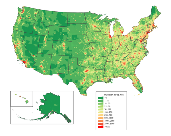
English:
United States population density map based on Census 2010 data. See the
data lineage
for a process description.
Also see
U.S. state population maps
.
|
||||||||
| Source | JimIrwin | ||||||||
| Author | User JimIrwin on en.wikipedia | ||||||||
|
Permission
( Reusing this file ) |
JimIrwin
at the
English-language Wikipedia
, the copyright holder of this work, hereby publishes it under the following license:
|
||||||||
| Other versions |
Originally from en.wikipedia ; description page is (was) here * 22:21, 20 March 2006 [[:en:User:JimIrwin|JimIrwin]] 1000×766 (119,253 bytes) <span class="comment">([[:en:Category:U.S. State Population Maps]] [[:en:Category:United States maps]] United States population density map based on Census 2000 data. See the [[:en:data lineage]] for a process description. )</span> |

(Uploaded using CommonsHelper or PushForCommons )