Villes_assyriennes.PNG

Size of this preview:
800 × 578 pixels
.
Other resolutions:
320 × 231 pixels
|
640 × 462 pixels
|
1,024 × 740 pixels
|
1,117 × 807 pixels
.

|
This
historical map
image could be re-created
using
vector graphics
as an
SVG
file
. This has several advantages; see
Commons:Media for cleanup
for more information. If an SVG form of this image is available, please upload it and afterwards replace this template with
{{

vector version available

|

new image name

}}
.
It is recommended to name the SVG file “Villes assyriennes.svg”—then the template Vector version available (or Vva ) does not need the new image name parameter. |
| Description |
English:
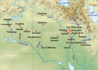
Map with the main cities of Assyria and Upper Mesopotamia during the medio-assyrian (ca. 1365-934 BC) and neo-assyrian period (ca. 934-609 BC).
Français :
Localisation des principales villes de l'Assyrie et de la Haute Mésopotamie durant les périodes médio-assyrienne (ca. 1365-934 av. J.-C.) et néo-assyrienne (ca. 934-609 av. J.-C.).
|
| Date | (UTC) |
| Source | |
| Author |
|
|
|
This is a
retouched picture
, which means that it has been digitally altered from its original version. Modifications:
Ajout des noms des villes et des cours d'eau.
. The original can be viewed here:
Near East topographic map-blank.svg
:
|
I, the copyright holder of this work, hereby publish it under the following licenses:
This file is licensed under the
Creative Commons
Attribution-Share Alike
3.0 Unported
,
2.5 Generic
,
2.0 Generic
and
1.0 Generic
license.
-
You are free:
- to share – to copy, distribute and transmit the work
- to remix – to adapt the work
-
Under the following conditions:
- attribution – You must give appropriate credit, provide a link to the license, and indicate if changes were made. You may do so in any reasonable manner, but not in any way that suggests the licensor endorses you or your use.
- share alike – If you remix, transform, or build upon the material, you must distribute your contributions under the same or compatible license as the original.

|
Permission is granted to copy, distribute and/or modify this document under the terms of the GNU Free Documentation License , Version 1.2 or any later version published by the Free Software Foundation ; with no Invariant Sections, no Front-Cover Texts, and no Back-Cover Texts. A copy of the license is included in the section entitled GNU Free Documentation License . |
You may select the license of your choice.
Original upload log
This image is a derivative work of the following images:
-
File:Near_East_topographic_map-blank.svg
licensed with Cc-by-sa-3.0,2.5,2.0,1.0, GFDL
- 2009-08-18T18:31:37Z Sémhur 2425x1581 (2442670 Bytes) 3 - New try
- 2009-08-17T15:39:22Z Sémhur 2425x1581 (1815374 Bytes) 2 - With the background...
- 2009-08-17T15:37:36Z Sémhur 2425x1581 (2836 Bytes) {{Information |Description={{en|1=Blank physical map of the [[:en:Near East|Near East]]}} {{fr|1=Carte physique vierge du [[:fr:Proche-Orient|Proche-Orient]].}} |Source={{own}} |Author=[[User:Sémhur|Sémhur]] |Date=2008-08-1
Uploaded with derivativeFX