Volcanic-ash-downfall_map_of_Mt.Fuji_Hoei-eruption01.jpg

Size of this preview:
800 × 564 pixels
.
Other resolutions:
320 × 226 pixels
|
640 × 451 pixels
|
1,024 × 722 pixels
|
1,280 × 902 pixels
|
1,935 × 1,364 pixels
.
Summary
| Description |
日本語:
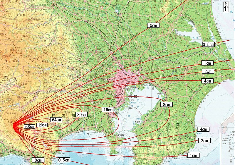
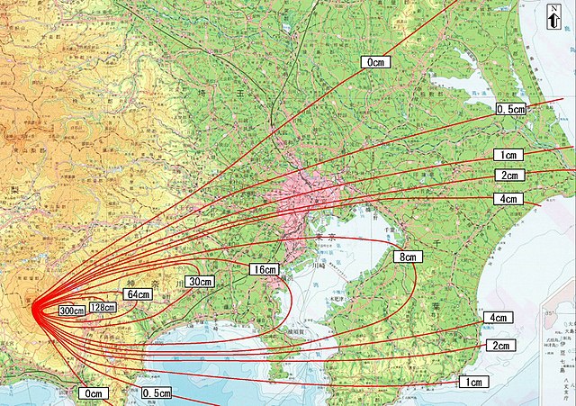
防災対応を検討するための降灰分布図(富士山宝永噴火)
English:
Ashfall distribution map for examining disaster prevention measures (Mt. Fuji Hoei eruption)
|
||
| Date | 中間報告〔平成14年6月12日〕(the interim report was released on 2002-6-12) | ||
| Source |
日本語:
富士山ハザードマップ検討委員会中間報告
English:
Mt. Fuji Hazard Map Review Committee Interim Report
http://www.bousai.go.jp/fujisan/h_map/kentou/interim_report/ http://www.bousai.go.jp/fujisan/h_map/kentou/interim_report/all_p.pdf 出典:富士山防災協議会( the Mt.Fuji Volcano Disaster Management Conference ) |
||
| Author | 富士山防災協議会 (Mt. Fuji Disaster Prevention Council); Miya.m added the URL and the information to the Map and uploaded under the permission of the Cabinet Office of the Japanese Government | ||
|
Permission
( Reusing this file ) |
This file is licensed under the
Creative Commons
Attribution 4.0 International
license.
Attribution:
内閣府防災のページ
|
||
| Other versions | Image:Hazard Map of Mt.Fuji common l.jpg |

Licensing
work of "the Mt.Fuji Volcano Disaster Management Conference" ( http://www.bousai.go.jp/fujisan-kyougikai/ archive copy at the Wayback Machine ) supported by Japanese government cabinet officials ( http://www.bousai.go.jp/ ); confirmed to be CC-by-4.0(cf: [1] )
This file is licensed under the
Creative Commons
Attribution 4.0 International
license.
-
You are free:
- to share – to copy, distribute and transmit the work
- to remix – to adapt the work
-
Under the following conditions:
- attribution – You must give appropriate credit, provide a link to the license, and indicate if changes were made. You may do so in any reasonable manner, but not in any way that suggests the licensor endorses you or your use.
-