WILSON'S_MILL,_FORMERLY_KNOWN_AS_ALEXANDER'S_MILL,_ON_THE_OHIO-ERIE_CANAL_SOUTH_OF_ALEXANDER_ROAD_NEAR_VALLEY_VIEW..._-_NARA_-_558001.jpg

|
|
This is an image of a place or building that is listed on the
National Register of Historic Places
in the
United States of America
. Its reference number is
79000298
.
|
Summary
| Author |
Frank J. (Frank John) Aleksandrowicz, 1921-, Photographer (
NARA record: 8452210
)
|
||||||||||||||||||||||||||
| Record creator | Environmental Protection Agency. (12/02/1970 - ) | ||||||||||||||||||||||||||
| Title |
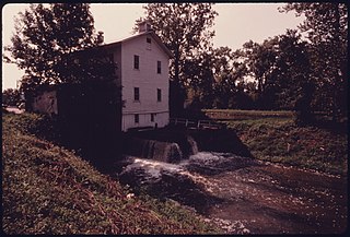
WILSON'S MILL, FORMERLY KNOWN AS ALEXANDER'S MILL, ON THE OHIO-ERIE CANAL SOUTH OF ALEXANDER ROAD NEAR VALLEY VIEW AND CLEVELAND, OHIO. WHEN IT OPERATED, CANAL WATER DROPPED THROUGH A SLUICE WHICH PROVIDED POWER TO GRIND GRAIN. THE CANAL CONNECTED THE GREAT LAKES WITH THE OHIO AND MISSISSIPPI RIVER SYSTEMS BETWEEN 1833 AND 1913 WHEN A FLOOD AND THE RAILROADS PUT THE WATERWAY OUT OF BUSINESS. THE SITE IS NOW PART OF THE CUYAHOGA VALLEY NATIONAL RECREATION AREA
|
||||||||||||||||||||||||||
| Depicted place |
Cleveland (Cuyahoga county, Ohio, United States, North and Central America) inhabited place (
41°28′59″N
81°40′59″W
/
41.483°N 81.683°W
;
NARA geographical record
)
|
||||||||||||||||||||||||||
| Date | September 1975 | ||||||||||||||||||||||||||
| Collection |
|
||||||||||||||||||||||||||
| Record ID |
NAIL Control Number: NWDNS-412-DA-15551
|
||||||||||||||||||||||||||
| Source | U.S. National Archives and Records Administration | ||||||||||||||||||||||||||
| Other versions |
Please
do not overwrite
this file:
any restoration work should be uploaded with a new name and linked in this page's "
other versions=
" parameter, so that this file represents the
exact
file found in the NARA catalog record to which it links. The metadata on this page was imported directly from NARA's catalog record; additional descriptive text may be added by Wikimedians to the template below with the "
description=
" parameter, but please do not modify the other fields.
|
||||||||||||||||||||||||||


Licensing
|
|
This file was provided to Wikimedia Commons by the
National Archives and Records Administration
as part of a
cooperation project
. The National Archives and Records Administration provides images depicting American and global history which are public domain or licensed under a free license.
|
|
|
This image (or other media) is a work of an
Environmental Protection Agency
employee, taken or made as part of that person's official duties. As
works
of the
U.S. federal government
, all EPA images are in the
public domain
.
|
|
| Object location |
|
View this and other nearby images on: OpenStreetMap |
|
|---|